You are here: Home > Network List > TA - USArray Transportable Network (new EarthScope stations) Stations List
> Station Y12C Blythe, CA, USA > Earthquake Result Viewer
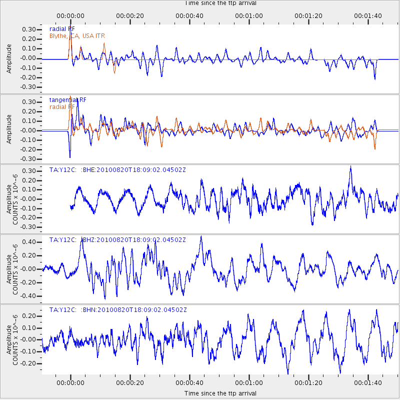
Y12C Blythe, CA, USA - Earthquake Result Viewer
*The percent match for this event was below the threshold and hence no stack was calculated.
| Earthquake location: |
Solomon Islands |
| Earthquake latitude/longitude: |
-6.6/154.2 |
| Earthquake time(UTC): |
2010/08/20 (232) 17:56:14 GMT |
| Earthquake Depth: |
19 km |
| Earthquake Magnitude: |
5.5 MB, 6.1 MS, 6.1 MW, 6.0 MW |
| Earthquake Catalog/Contributor: |
WHDF/NEIC |
|
| Network: |
TA USArray Transportable Network (new EarthScope stations) |
| Station: |
Y12C Blythe, CA, USA |
| Lat/Lon: |
33.75 N/114.52 W |
| Elevation: |
196 m |
|
| Distance: |
94.6 deg |
| Az: |
56.69 deg |
| Baz: |
265.229 deg |
| Ray Param: |
$rayparam |
*The percent match for this event was below the threshold and hence was not used in the summary stack. |
|
| Radial Match: |
61.967815 % |
| Radial Bump: |
400 |
| Transverse Match: |
75.202805 % |
| Transverse Bump: |
400 |
| SOD ConfigId: |
319893 |
| Insert Time: |
2011-01-06 01:05:46.424 +0000 |
| GWidth: |
2.5 |
| Max Bumps: |
400 |
| Tol: |
0.001 |
|
Signal To Noise
| Channel | StoN | STA | LTA |
| TA:Y12C: :BHZ:20100820T18:09:02.04502Z | 3.0605023 | 2.0427278E-7 | 6.674485E-8 |
| TA:Y12C: :BHN:20100820T18:09:02.04502Z | 0.45077524 | 4.0719033E-8 | 9.033112E-8 |
| TA:Y12C: :BHE:20100820T18:09:02.04502Z | 1.1075424 | 8.7528626E-8 | 7.902959E-8 |
| Arrivals |
| Ps | |
| PpPs | |
| PsPs/PpSs | |


