You are here: Home > Network List > PS - Pacific21 Stations List
> Station PSI Parapat, Indonesia > Earthquake Result Viewer
PSI Parapat, Indonesia - Earthquake Result Viewer
| Earthquake location: |
Irian Jaya, Indonesia |
| Earthquake latitude/longitude: |
-3.2/139.3 |
| Earthquake time(UTC): |
2023/12/30 (364) 17:16:23 GMT |
| Earthquake Depth: |
10 km |
| Earthquake Magnitude: |
6.5 Mi |
| Earthquake Catalog/Contributor: |
NEIC PDE/pt |
|
| Network: |
PS Pacific21 |
| Station: |
PSI Parapat, Indonesia |
| Lat/Lon: |
2.69 N/98.92 E |
| Elevation: |
987 m |
|
| Distance: |
40.8 deg |
| Az: |
277.823 deg |
| Baz: |
98.009 deg |
| Ray Param: |
0.07420594 |
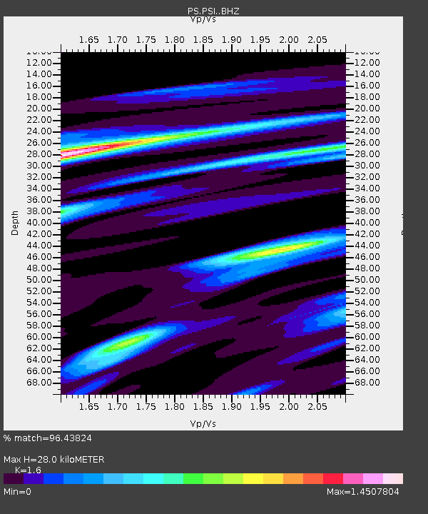
| Estimated Moho Depth: |
28.0 km |
| Estimated Crust Vp/Vs: |
1.60 |
| Assumed Crust Vp: |
6.468 km/s |
| Estimated Crust Vs: |
4.042 km/s |
| Estimated Crust Poisson's Ratio: |
0.18 |
|
| Radial Match: |
96.43824 % |
| Radial Bump: |
339 |
| Transverse Match: |
93.2586 % |
| Transverse Bump: |
400 |
| SOD ConfigId: |
33437571 |
| Insert Time: |
2024-01-13 17:31:19.428 +0000 |
| GWidth: |
2.5 |
| Max Bumps: |
400 |
| Tol: |
0.001 |
|
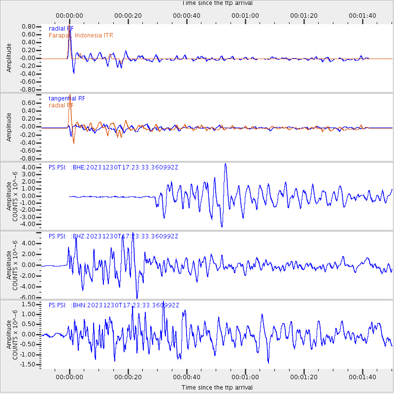
Signal To Noise
| Channel | StoN | STA | LTA |
| PS:PSI: :BHZ:20231230T17:23:33.360992Z | 55.552917 | 2.3989887E-6 | 4.318385E-8 |
| PS:PSI: :BHN:20231230T17:23:33.360992Z | 7.60077 | 3.1743966E-7 | 4.1764142E-8 |
| PS:PSI: :BHE:20231230T17:23:33.360992Z | 32.939487 | 1.4174199E-6 | 4.3031026E-8 |
| Arrivals |
| Ps | 2.8 SECOND |
| PpPs | 10 SECOND |
| PsPs/PpSs | 13 SECOND |


