You are here: Home > Network List > US - United States National Seismic Network Stations List
> Station HAWA Hanford, Washington, USA > Earthquake Result Viewer
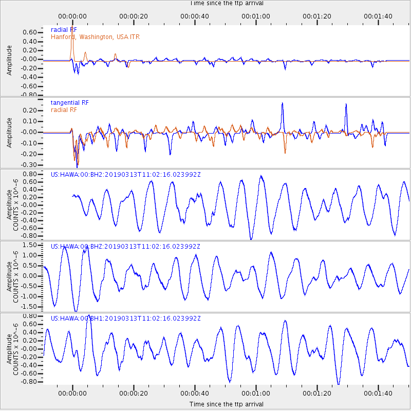
HAWA Hanford, Washington, USA - Earthquake Result Viewer
*The percent match for this event was below the threshold and hence no stack was calculated.
| Earthquake location: |
Hawaii |
| Earthquake latitude/longitude: |
19.3/-155.2 |
| Earthquake time(UTC): |
2019/03/13 (072) 10:55:13 GMT |
| Earthquake Depth: |
7.0 km |
| Earthquake Magnitude: |
5.5 Ml |
| Earthquake Catalog/Contributor: |
NEIC PDE/hv |
|
| Network: |
US United States National Seismic Network |
| Station: |
HAWA Hanford, Washington, USA |
| Lat/Lon: |
46.39 N/119.53 W |
| Elevation: |
364 m |
|
| Distance: |
39.8 deg |
| Az: |
39.099 deg |
| Baz: |
239.369 deg |
| Ray Param: |
$rayparam |
*The percent match for this event was below the threshold and hence was not used in the summary stack. |
|
| Radial Match: |
74.67035 % |
| Radial Bump: |
400 |
| Transverse Match: |
72.22991 % |
| Transverse Bump: |
400 |
| SOD ConfigId: |
3338192 |
| Insert Time: |
2019-03-27 11:21:08.318 +0000 |
| GWidth: |
2.5 |
| Max Bumps: |
400 |
| Tol: |
0.001 |
|
Signal To Noise
| Channel | StoN | STA | LTA |
| US:HAWA:00:BHZ:20190313T11:02:16.023992Z | 1.904754 | 1.141071E-6 | 5.990647E-7 |
| US:HAWA:00:BH1:20190313T11:02:16.023992Z | 0.9062552 | 3.272273E-7 | 3.6107633E-7 |
| US:HAWA:00:BH2:20190313T11:02:16.023992Z | 1.3566302 | 3.929772E-7 | 2.8967156E-7 |
| Arrivals |
| Ps | |
| PpPs | |
| PsPs/PpSs | |


