You are here: Home > Network List > UU - University of Utah Regional Network Stations List
> Station KNB Kanab, UT, USA > Earthquake Result Viewer
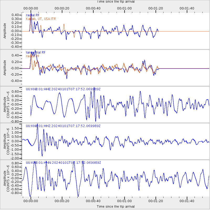
KNB Kanab, UT, USA - Earthquake Result Viewer
*The percent match for this event was below the threshold and hence no stack was calculated.
| Earthquake location: |
Near West Coast Of Honshu, Japan |
| Earthquake latitude/longitude: |
37.5/137.2 |
| Earthquake time(UTC): |
2024/01/01 (001) 07:06:05 GMT |
| Earthquake Depth: |
10 km |
| Earthquake Magnitude: |
5.5 mww |
| Earthquake Catalog/Contributor: |
NEIC PDE/us |
|
| Network: |
UU University of Utah Regional Network |
| Station: |
KNB Kanab, UT, USA |
| Lat/Lon: |
37.02 N/112.82 W |
| Elevation: |
1715 m |
|
| Distance: |
81.6 deg |
| Az: |
49.518 deg |
| Baz: |
310.912 deg |
| Ray Param: |
$rayparam |
*The percent match for this event was below the threshold and hence was not used in the summary stack. |
|
| Radial Match: |
73.93671 % |
| Radial Bump: |
400 |
| Transverse Match: |
63.512142 % |
| Transverse Bump: |
400 |
| SOD ConfigId: |
33437571 |
| Insert Time: |
2024-01-15 07:33:54.787 +0000 |
| GWidth: |
2.5 |
| Max Bumps: |
400 |
| Tol: |
0.001 |
|
Signal To Noise
| Channel | StoN | STA | LTA |
| UU:KNB:01:HHZ:20240101T07:17:52.069989Z | 2.5220456 | 7.109479E-7 | 2.8189336E-7 |
| UU:KNB:01:HHN:20240101T07:17:52.069989Z | 2.7493885 | 6.628278E-7 | 2.410819E-7 |
| UU:KNB:01:HHE:20240101T07:17:52.069989Z | 1.0174019 | 2.8647477E-7 | 2.815748E-7 |
| Arrivals |
| Ps | |
| PpPs | |
| PsPs/PpSs | |


