You are here: Home > Network List > IW - Intermountain West Stations List
> Station PLID Pearl Lake, Idaho, USA > Earthquake Result Viewer
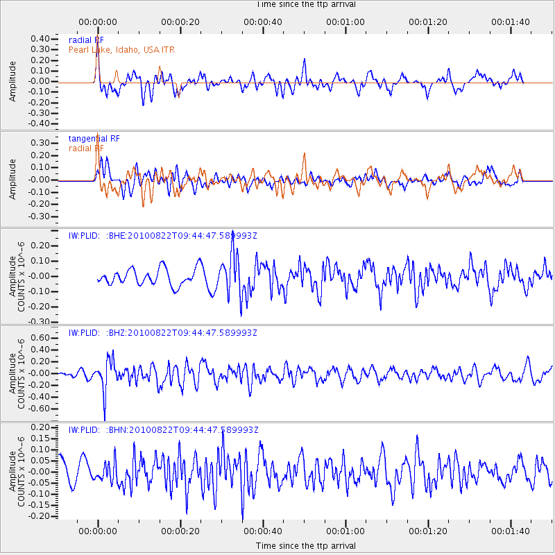
PLID Pearl Lake, Idaho, USA - Earthquake Result Viewer
*The percent match for this event was below the threshold and hence no stack was calculated.
| Earthquake location: |
Mariana Islands Region |
| Earthquake latitude/longitude: |
19.4/147.4 |
| Earthquake time(UTC): |
2010/08/22 (234) 09:33:06 GMT |
| Earthquake Depth: |
23 km |
| Earthquake Magnitude: |
5.9 MB, 5.3 MS, 5.5 MW |
| Earthquake Catalog/Contributor: |
WHDF/NEIC |
|
| Network: |
IW Intermountain West |
| Station: |
PLID Pearl Lake, Idaho, USA |
| Lat/Lon: |
45.09 N/116.00 W |
| Elevation: |
2164 m |
|
| Distance: |
81.0 deg |
| Az: |
45.434 deg |
| Baz: |
288.364 deg |
| Ray Param: |
$rayparam |
*The percent match for this event was below the threshold and hence was not used in the summary stack. |
|
| Radial Match: |
71.94001 % |
| Radial Bump: |
400 |
| Transverse Match: |
65.83587 % |
| Transverse Bump: |
400 |
| SOD ConfigId: |
319893 |
| Insert Time: |
2011-01-06 01:22:53.587 +0000 |
| GWidth: |
2.5 |
| Max Bumps: |
400 |
| Tol: |
0.001 |
|
Signal To Noise
| Channel | StoN | STA | LTA |
| IW:PLID: :BHZ:20100822T09:44:47.589993Z | 3.952931 | 2.633461E-7 | 6.6620466E-8 |
| IW:PLID: :BHN:20100822T09:44:47.589993Z | 1.0420449 | 4.0827732E-8 | 3.91804E-8 |
| IW:PLID: :BHE:20100822T09:44:47.589993Z | 2.5949104 | 1.3451582E-7 | 5.1838327E-8 |
| Arrivals |
| Ps | |
| PpPs | |
| PsPs/PpSs | |


