You are here: Home > Network List > AK - Alaska Regional Network Stations List
> Station CUT Chulitna, AK, USA > Earthquake Result Viewer
CUT Chulitna, AK, USA - Earthquake Result Viewer
| Earthquake location: |
Near West Coast Of Honshu, Japan |
| Earthquake latitude/longitude: |
37.5/137.2 |
| Earthquake time(UTC): |
2024/01/01 (001) 07:10:10 GMT |
| Earthquake Depth: |
0.0 km |
| Earthquake Magnitude: |
7.4 Mi |
| Earthquake Catalog/Contributor: |
NEIC PDE/pt |
|
| Network: |
AK Alaska Regional Network |
| Station: |
CUT Chulitna, AK, USA |
| Lat/Lon: |
62.41 N/150.26 W |
| Elevation: |
574 m |
|
| Distance: |
49.6 deg |
| Az: |
35.657 deg |
| Baz: |
275.351 deg |
| Ray Param: |
0.0686143 |
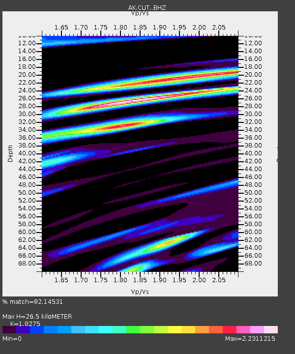
| Estimated Moho Depth: |
26.5 km |
| Estimated Crust Vp/Vs: |
1.83 |
| Assumed Crust Vp: |
6.438 km/s |
| Estimated Crust Vs: |
3.523 km/s |
| Estimated Crust Poisson's Ratio: |
0.29 |
|
| Radial Match: |
92.14531 % |
| Radial Bump: |
400 |
| Transverse Match: |
80.50696 % |
| Transverse Bump: |
400 |
| SOD ConfigId: |
33437571 |
| Insert Time: |
2024-01-15 07:39:39.941 +0000 |
| GWidth: |
2.5 |
| Max Bumps: |
400 |
| Tol: |
0.001 |
|

Signal To Noise
| Channel | StoN | STA | LTA |
| AK:CUT: :BHZ:20240101T07:18:32.23999Z | 4.830865 | 1.8873424E-6 | 3.9068414E-7 |
| AK:CUT: :BHN:20240101T07:18:32.23999Z | 0.9378333 | 6.5628836E-7 | 6.997921E-7 |
| AK:CUT: :BHE:20240101T07:18:32.23999Z | 2.1695857 | 1.1723823E-6 | 5.4037156E-7 |
| Arrivals |
| Ps | 3.6 SECOND |
| PpPs | 11 SECOND |
| PsPs/PpSs | 15 SECOND |


