You are here: Home > Network List > AK - Alaska Regional Network Stations List
> Station PS07 TAPS Pump Station 7, AK, USA > Earthquake Result Viewer
PS07 TAPS Pump Station 7, AK, USA - Earthquake Result Viewer
| Earthquake location: |
Near West Coast Of Honshu, Japan |
| Earthquake latitude/longitude: |
37.5/137.2 |
| Earthquake time(UTC): |
2024/01/01 (001) 07:10:10 GMT |
| Earthquake Depth: |
0.0 km |
| Earthquake Magnitude: |
7.4 Mi |
| Earthquake Catalog/Contributor: |
NEIC PDE/pt |
|
| Network: |
AK Alaska Regional Network |
| Station: |
PS07 TAPS Pump Station 7, AK, USA |
| Lat/Lon: |
65.31 N/148.28 W |
| Elevation: |
289 m |
|
| Distance: |
50.3 deg |
| Az: |
31.762 deg |
| Baz: |
274.623 deg |
| Ray Param: |
0.06820103 |
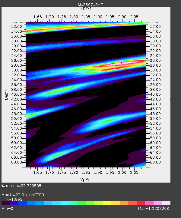
| Estimated Moho Depth: |
27.0 km |
| Estimated Crust Vp/Vs: |
2.00 |
| Assumed Crust Vp: |
6.566 km/s |
| Estimated Crust Vs: |
3.291 km/s |
| Estimated Crust Poisson's Ratio: |
0.33 |
|
| Radial Match: |
97.720535 % |
| Radial Bump: |
400 |
| Transverse Match: |
84.981415 % |
| Transverse Bump: |
400 |
| SOD ConfigId: |
33437571 |
| Insert Time: |
2024-01-15 07:41:43.169 +0000 |
| GWidth: |
2.5 |
| Max Bumps: |
400 |
| Tol: |
0.001 |
|

Signal To Noise
| Channel | StoN | STA | LTA |
| AK:PS07: :BHZ:20240101T07:18:36.947998Z | 4.112455 | 1.4245092E-6 | 3.4638902E-7 |
| AK:PS07: :BHN:20240101T07:18:36.947998Z | 0.92890316 | 2.719833E-7 | 2.9280048E-7 |
| AK:PS07: :BHE:20240101T07:18:36.947998Z | 2.1933322 | 9.446048E-7 | 4.3067112E-7 |
| Arrivals |
| Ps | 4.3 SECOND |
| PpPs | 12 SECOND |
| PsPs/PpSs | 16 SECOND |


