You are here: Home > Network List > TA - USArray Transportable Network (new EarthScope stations) Stations List
> Station I23A Meade Ranch, Gillette, WY, USA > Earthquake Result Viewer
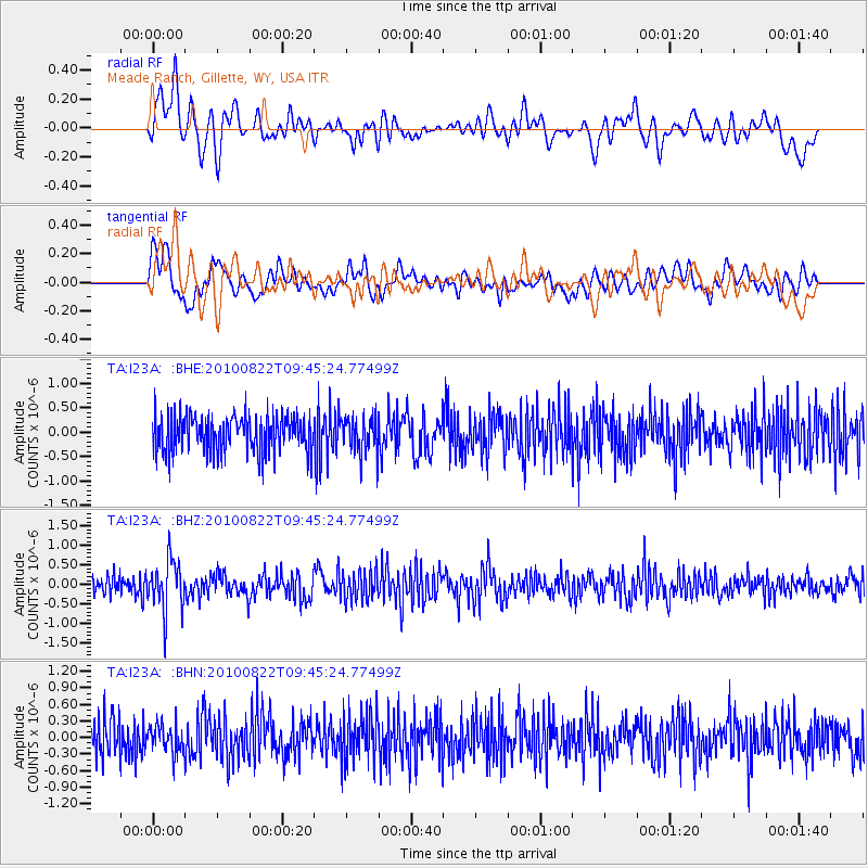
I23A Meade Ranch, Gillette, WY, USA - Earthquake Result Viewer
*The percent match for this event was below the threshold and hence no stack was calculated.
| Earthquake location: |
Mariana Islands Region |
| Earthquake latitude/longitude: |
19.4/147.4 |
| Earthquake time(UTC): |
2010/08/22 (234) 09:33:06 GMT |
| Earthquake Depth: |
23 km |
| Earthquake Magnitude: |
5.9 MB, 5.3 MS, 5.5 MW |
| Earthquake Catalog/Contributor: |
WHDF/NEIC |
|
| Network: |
TA USArray Transportable Network (new EarthScope stations) |
| Station: |
I23A Meade Ranch, Gillette, WY, USA |
| Lat/Lon: |
43.96 N/105.46 W |
| Elevation: |
1462 m |
|
| Distance: |
88.4 deg |
| Az: |
43.651 deg |
| Baz: |
295.573 deg |
| Ray Param: |
$rayparam |
*The percent match for this event was below the threshold and hence was not used in the summary stack. |
|
| Radial Match: |
59.613224 % |
| Radial Bump: |
400 |
| Transverse Match: |
58.82804 % |
| Transverse Bump: |
400 |
| SOD ConfigId: |
319893 |
| Insert Time: |
2011-01-06 01:28:06.790 +0000 |
| GWidth: |
2.5 |
| Max Bumps: |
400 |
| Tol: |
0.001 |
|
Signal To Noise
| Channel | StoN | STA | LTA |
| TA:I23A: :BHZ:20100822T09:45:24.77499Z | 2.819368 | 6.3499954E-7 | 2.2522764E-7 |
| TA:I23A: :BHN:20100822T09:45:24.77499Z | 0.7930079 | 2.5373376E-7 | 3.1996373E-7 |
| TA:I23A: :BHE:20100822T09:45:24.77499Z | 0.9958421 | 3.7401685E-7 | 3.7557848E-7 |
| Arrivals |
| Ps | |
| PpPs | |
| PsPs/PpSs | |


