You are here: Home > Network List > CC - Cascade Chain Volcano Monitoring Stations List
> Station HUSB The Husband > Earthquake Result Viewer
HUSB The Husband - Earthquake Result Viewer
| Earthquake location: |
Near West Coast Of Honshu, Japan |
| Earthquake latitude/longitude: |
37.5/137.2 |
| Earthquake time(UTC): |
2024/01/01 (001) 07:10:10 GMT |
| Earthquake Depth: |
0.0 km |
| Earthquake Magnitude: |
7.4 Mi |
| Earthquake Catalog/Contributor: |
NEIC PDE/pt |
|
| Network: |
CC Cascade Chain Volcano Monitoring |
| Station: |
HUSB The Husband |
| Lat/Lon: |
44.12 N/121.85 W |
| Elevation: |
2038 m |
|
| Distance: |
71.8 deg |
| Az: |
48.09 deg |
| Baz: |
304.736 deg |
| Ray Param: |
0.054093014 |
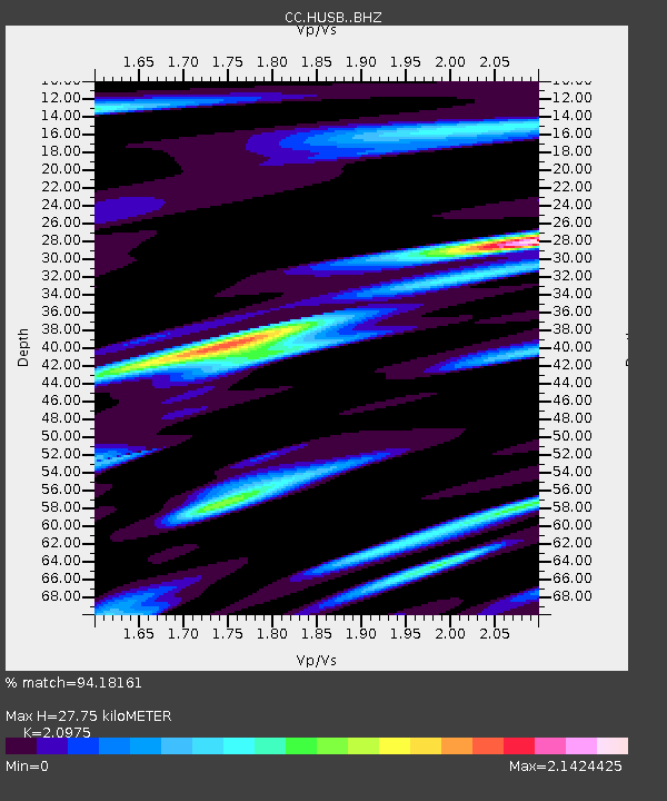
| Estimated Moho Depth: |
27.75 km |
| Estimated Crust Vp/Vs: |
2.10 |
| Assumed Crust Vp: |
6.597 km/s |
| Estimated Crust Vs: |
3.145 km/s |
| Estimated Crust Poisson's Ratio: |
0.35 |
|
| Radial Match: |
94.18161 % |
| Radial Bump: |
400 |
| Transverse Match: |
87.50667 % |
| Transverse Bump: |
400 |
| SOD ConfigId: |
33437571 |
| Insert Time: |
2024-01-15 07:47:43.139 +0000 |
| GWidth: |
2.5 |
| Max Bumps: |
400 |
| Tol: |
0.001 |
|

Signal To Noise
| Channel | StoN | STA | LTA |
| CC:HUSB: :BHZ:20240101T07:21:03.200012Z | 5.1308765 | 1.7658349E-6 | 3.4415854E-7 |
| CC:HUSB: :BHN:20240101T07:21:03.200012Z | 2.1533308 | 1.0832431E-6 | 5.030547E-7 |
| CC:HUSB: :BHE:20240101T07:21:03.200012Z | 2.0041873 | 1.0051161E-6 | 5.0150805E-7 |
| Arrivals |
| Ps | 4.8 SECOND |
| PpPs | 13 SECOND |
| PsPs/PpSs | 17 SECOND |


