You are here: Home > Network List > CC - Cascade Chain Volcano Monitoring Stations List
> Station KWBU Kawak Butte > Earthquake Result Viewer
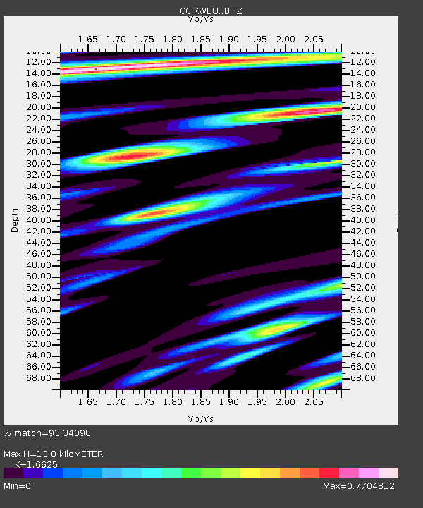
KWBU Kawak Butte - Earthquake Result Viewer
| Earthquake location: |
Near West Coast Of Honshu, Japan |
| Earthquake latitude/longitude: |
37.5/137.2 |
| Earthquake time(UTC): |
2024/01/01 (001) 07:10:10 GMT |
| Earthquake Depth: |
0.0 km |
| Earthquake Magnitude: |
7.4 Mi |
| Earthquake Catalog/Contributor: |
NEIC PDE/pt |
|
| Network: |
CC Cascade Chain Volcano Monitoring |
| Station: |
KWBU Kawak Butte |
| Lat/Lon: |
43.75 N/121.31 W |
| Elevation: |
1783 m |
|
| Distance: |
72.4 deg |
| Az: |
48.172 deg |
| Baz: |
305.133 deg |
| Ray Param: |
0.05373072 |
| Estimated Moho Depth: |
13.0 km |
| Estimated Crust Vp/Vs: |
1.66 |
| Assumed Crust Vp: |
6.597 km/s |
| Estimated Crust Vs: |
3.968 km/s |
| Estimated Crust Poisson's Ratio: |
0.22 |
|
| Radial Match: |
93.34098 % |
| Radial Bump: |
400 |
| Transverse Match: |
93.107285 % |
| Transverse Bump: |
400 |
| SOD ConfigId: |
33437571 |
| Insert Time: |
2024-01-15 07:47:48.619 +0000 |
| GWidth: |
2.5 |
| Max Bumps: |
400 |
| Tol: |
0.001 |
|

Signal To Noise
| Channel | StoN | STA | LTA |
| CC:KWBU: :BHZ:20240101T07:21:06.359985Z | 6.3202424 | 1.8459638E-6 | 2.920717E-7 |
| CC:KWBU: :BHN:20240101T07:21:06.359985Z | 0.6378237 | 2.3579992E-7 | 3.696945E-7 |
| CC:KWBU: :BHE:20240101T07:21:06.359985Z | 2.1335442 | 7.1308057E-7 | 3.3422347E-7 |
| Arrivals |
| Ps | 1.4 SECOND |
| PpPs | 5.0 SECOND |
| PsPs/PpSs | 6.4 SECOND |


