You are here: Home > Network List > CC - Cascade Chain Volcano Monitoring Stations List
> Station MILD Mildred Point > Earthquake Result Viewer
MILD Mildred Point - Earthquake Result Viewer
| Earthquake location: |
Near West Coast Of Honshu, Japan |
| Earthquake latitude/longitude: |
37.5/137.2 |
| Earthquake time(UTC): |
2024/01/01 (001) 07:10:10 GMT |
| Earthquake Depth: |
0.0 km |
| Earthquake Magnitude: |
7.4 Mi |
| Earthquake Catalog/Contributor: |
NEIC PDE/pt |
|
| Network: |
CC Cascade Chain Volcano Monitoring |
| Station: |
MILD Mildred Point |
| Lat/Lon: |
46.81 N/121.78 W |
| Elevation: |
2016 m |
|
| Distance: |
70.4 deg |
| Az: |
45.713 deg |
| Baz: |
304.018 deg |
| Ray Param: |
0.055071082 |
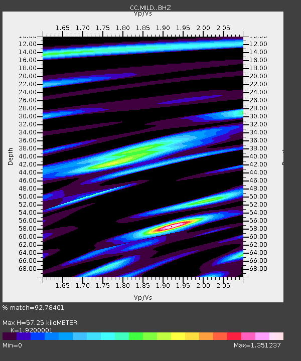
| Estimated Moho Depth: |
57.25 km |
| Estimated Crust Vp/Vs: |
1.92 |
| Assumed Crust Vp: |
6.597 km/s |
| Estimated Crust Vs: |
3.436 km/s |
| Estimated Crust Poisson's Ratio: |
0.31 |
|
| Radial Match: |
92.78401 % |
| Radial Bump: |
400 |
| Transverse Match: |
93.296455 % |
| Transverse Bump: |
400 |
| SOD ConfigId: |
33437571 |
| Insert Time: |
2024-01-15 07:47:53.682 +0000 |
| GWidth: |
2.5 |
| Max Bumps: |
400 |
| Tol: |
0.001 |
|

Signal To Noise
| Channel | StoN | STA | LTA |
| CC:MILD: :BHZ:20240101T07:20:54.280029Z | 7.542111 | 1.2198855E-6 | 1.6174324E-7 |
| CC:MILD: :BHN:20240101T07:20:54.280029Z | 2.614446 | 6.4652295E-7 | 2.472887E-7 |
| CC:MILD: :BHE:20240101T07:20:54.280029Z | 3.1382046 | 6.8773966E-7 | 2.1915068E-7 |
| Arrivals |
| Ps | 8.3 SECOND |
| PpPs | 24 SECOND |
| PsPs/PpSs | 33 SECOND |


