You are here: Home > Network List > CC - Cascade Chain Volcano Monitoring Stations List
> Station PALM Top of Palmer Lift > Earthquake Result Viewer
PALM Top of Palmer Lift - Earthquake Result Viewer
| Earthquake location: |
Near West Coast Of Honshu, Japan |
| Earthquake latitude/longitude: |
37.5/137.2 |
| Earthquake time(UTC): |
2024/01/01 (001) 07:10:10 GMT |
| Earthquake Depth: |
0.0 km |
| Earthquake Magnitude: |
7.4 Mi |
| Earthquake Catalog/Contributor: |
NEIC PDE/pt |
|
| Network: |
CC Cascade Chain Volcano Monitoring |
| Station: |
PALM Top of Palmer Lift |
| Lat/Lon: |
45.36 N/121.71 W |
| Elevation: |
2590 m |
|
| Distance: |
71.2 deg |
| Az: |
46.953 deg |
| Baz: |
304.477 deg |
| Ray Param: |
0.054492265 |
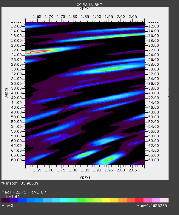
| Estimated Moho Depth: |
22.75 km |
| Estimated Crust Vp/Vs: |
1.62 |
| Assumed Crust Vp: |
6.597 km/s |
| Estimated Crust Vs: |
4.073 km/s |
| Estimated Crust Poisson's Ratio: |
0.19 |
|
| Radial Match: |
83.96589 % |
| Radial Bump: |
400 |
| Transverse Match: |
90.19711 % |
| Transverse Bump: |
400 |
| SOD ConfigId: |
33437571 |
| Insert Time: |
2024-01-15 07:48:00.417 +0000 |
| GWidth: |
2.5 |
| Max Bumps: |
400 |
| Tol: |
0.001 |
|

Signal To Noise
| Channel | StoN | STA | LTA |
| CC:PALM: :BHZ:20240101T07:20:59.47998Z | 4.324944 | 2.0501275E-6 | 4.7402406E-7 |
| CC:PALM: :BHN:20240101T07:20:59.47998Z | 1.8553126 | 1.0178909E-6 | 5.486358E-7 |
| CC:PALM: :BHE:20240101T07:20:59.47998Z | 4.381156 | 1.3989153E-6 | 3.1930276E-7 |
| Arrivals |
| Ps | 2.2 SECOND |
| PpPs | 8.7 SECOND |
| PsPs/PpSs | 11 SECOND |


