You are here: Home > Network List > GM - US Geological Survey Networks Stations List
> Station IWM01 Jericho 2M Well Monitoring Station > Earthquake Result Viewer
IWM01 Jericho 2M Well Monitoring Station - Earthquake Result Viewer
| Earthquake location: |
Central Bolivia |
| Earthquake latitude/longitude: |
-17.9/-65.9 |
| Earthquake time(UTC): |
2019/03/15 (074) 05:03:50 GMT |
| Earthquake Depth: |
358 km |
| Earthquake Magnitude: |
6.3 Mww |
| Earthquake Catalog/Contributor: |
NEIC PDE/us |
|
| Network: |
GM US Geological Survey Networks |
| Station: |
IWM01 Jericho 2M Well Monitoring Station |
| Lat/Lon: |
36.73 N/96.53 W |
| Elevation: |
328 m |
|
| Distance: |
61.5 deg |
| Az: |
332.235 deg |
| Baz: |
146.479 deg |
| Ray Param: |
0.05959978 |
| Estimated Moho Depth: |
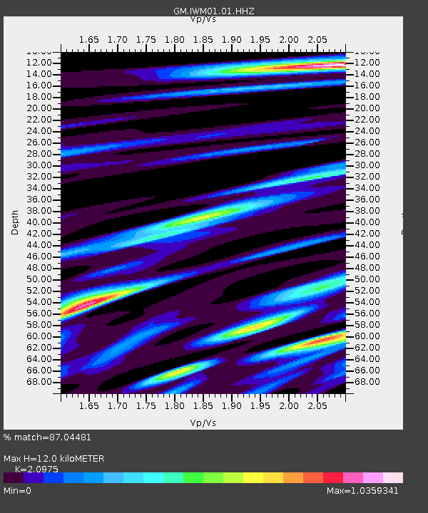
12.0 km |
| Estimated Crust Vp/Vs: |
2.10 |
| Assumed Crust Vp: |
6.483 km/s |
| Estimated Crust Vs: |
3.091 km/s |
| Estimated Crust Poisson's Ratio: |
0.35 |
|
| Radial Match: |
87.04481 % |
| Radial Bump: |
400 |
| Transverse Match: |
49.923607 % |
| Transverse Bump: |
400 |
| SOD ConfigId: |
3338192 |
| Insert Time: |
2019-03-29 05:19:34.125 +0000 |
| GWidth: |
2.5 |
| Max Bumps: |
400 |
| Tol: |
0.001 |
|
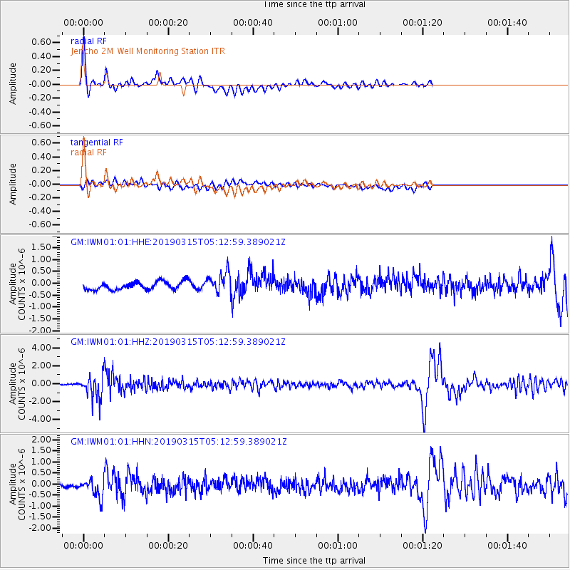
Signal To Noise
| Channel | StoN | STA | LTA |
| GM:IWM01:01:HHZ:20190315T05:12:59.389021Z | 15.265001 | 1.2671798E-6 | 8.30121E-8 |
| GM:IWM01:01:HHN:20190315T05:12:59.389021Z | 2.986451 | 4.5976418E-7 | 1.5395001E-7 |
| GM:IWM01:01:HHE:20190315T05:12:59.389021Z | 2.6758623 | 4.4758286E-7 | 1.6726678E-7 |
| Arrivals |
| Ps | 2.1 SECOND |
| PpPs | 5.5 SECOND |
| PsPs/PpSs | 7.6 SECOND |


