You are here: Home > Network List > CI - Caltech Regional Seismic Network Stations List
> Station SMM Simmler, CA, USA > Earthquake Result Viewer
SMM Simmler, CA, USA - Earthquake Result Viewer
| Earthquake location: |
Near West Coast Of Honshu, Japan |
| Earthquake latitude/longitude: |
37.5/137.2 |
| Earthquake time(UTC): |
2024/01/01 (001) 07:10:10 GMT |
| Earthquake Depth: |
0.0 km |
| Earthquake Magnitude: |
7.4 Mi |
| Earthquake Catalog/Contributor: |
NEIC PDE/pt |
|
| Network: |
CI Caltech Regional Seismic Network |
| Station: |
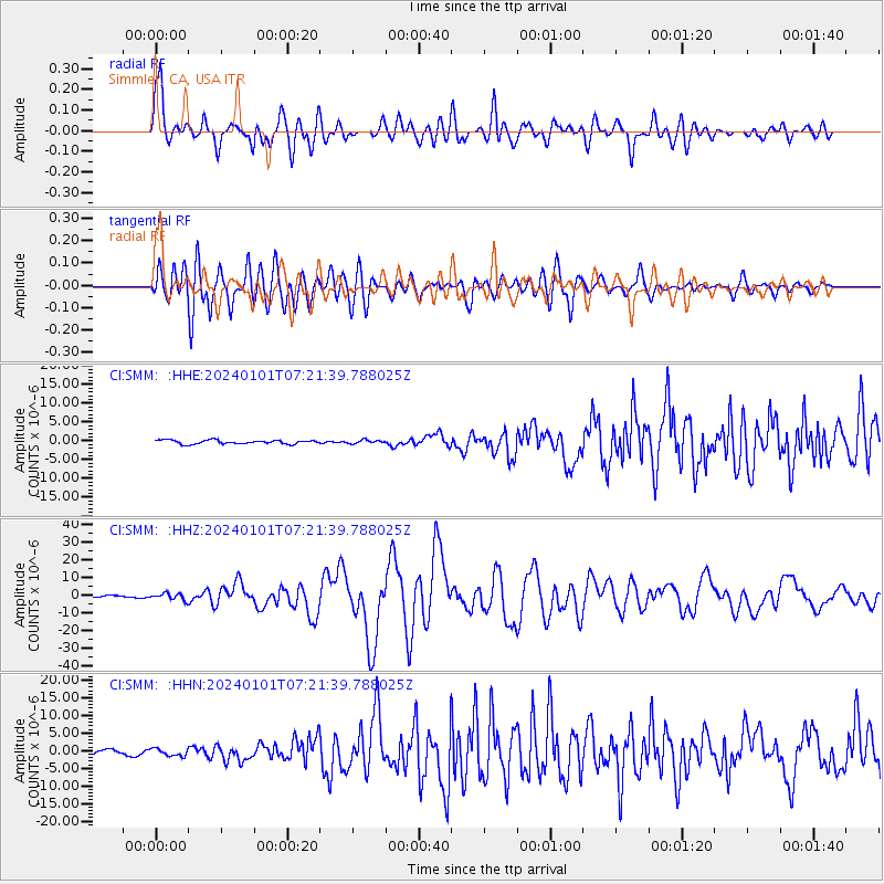
SMM Simmler, CA, USA |
| Lat/Lon: |
35.31 N/120.00 W |
| Elevation: |
599 m |
|
| Distance: |
78.2 deg |
| Az: |
54.561 deg |
| Baz: |
307.597 deg |
| Ray Param: |
0.04983949 |
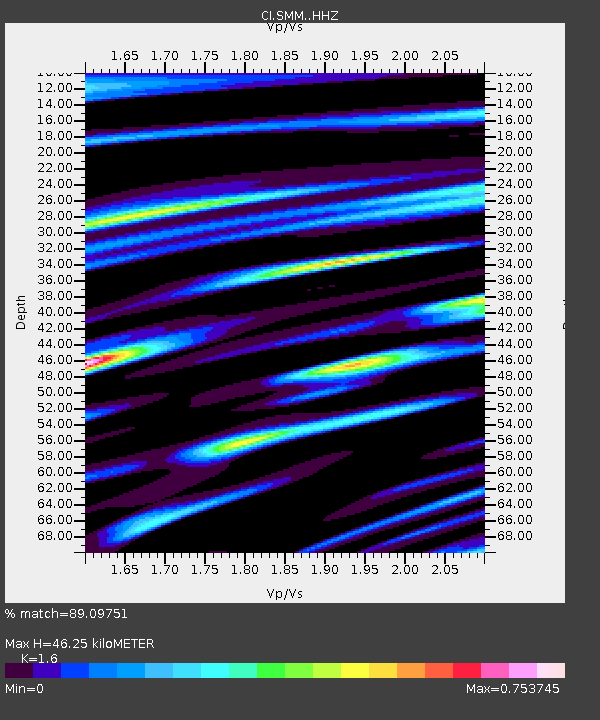
| Estimated Moho Depth: |
46.25 km |
| Estimated Crust Vp/Vs: |
1.60 |
| Assumed Crust Vp: |
6.1 km/s |
| Estimated Crust Vs: |
3.812 km/s |
| Estimated Crust Poisson's Ratio: |
0.18 |
|
| Radial Match: |
89.09751 % |
| Radial Bump: |
400 |
| Transverse Match: |
89.63516 % |
| Transverse Bump: |
400 |
| SOD ConfigId: |
33437571 |
| Insert Time: |
2024-01-15 07:50:33.204 +0000 |
| GWidth: |
2.5 |
| Max Bumps: |
400 |
| Tol: |
0.001 |
|
Signal To Noise
| Channel | StoN | STA | LTA |
| CI:SMM: :HHZ:20240101T07:21:39.788025Z | 2.9955661 | 1.8576912E-6 | 6.20147E-7 |
| CI:SMM: :HHN:20240101T07:21:39.788025Z | 1.8670951 | 1.0376083E-6 | 5.55734E-7 |
| CI:SMM: :HHE:20240101T07:21:39.788025Z | 0.893714 | 4.577282E-7 | 5.1216404E-7 |
| Arrivals |
| Ps | 4.7 SECOND |
| PpPs | 19 SECOND |
| PsPs/PpSs | 24 SECOND |


