You are here: Home > Network List > TA - USArray Transportable Network (new EarthScope stations) Stations List
> Station V29A Stinnett, TX, USA > Earthquake Result Viewer
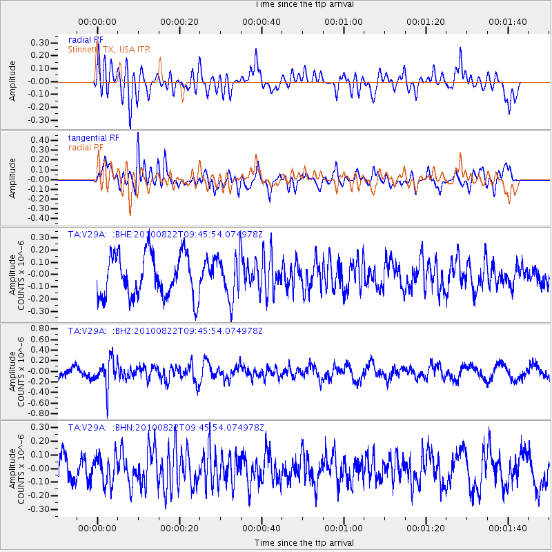
V29A Stinnett, TX, USA - Earthquake Result Viewer
*The percent match for this event was below the threshold and hence no stack was calculated.
| Earthquake location: |
Mariana Islands Region |
| Earthquake latitude/longitude: |
19.4/147.4 |
| Earthquake time(UTC): |
2010/08/22 (234) 09:33:06 GMT |
| Earthquake Depth: |
23 km |
| Earthquake Magnitude: |
5.9 MB, 5.3 MS, 5.5 MW |
| Earthquake Catalog/Contributor: |
WHDF/NEIC |
|
| Network: |
TA USArray Transportable Network (new EarthScope stations) |
| Station: |
V29A Stinnett, TX, USA |
| Lat/Lon: |
35.87 N/101.52 W |
| Elevation: |
953 m |
|
| Distance: |
94.8 deg |
| Az: |
49.494 deg |
| Baz: |
297.938 deg |
| Ray Param: |
$rayparam |
*The percent match for this event was below the threshold and hence was not used in the summary stack. |
|
| Radial Match: |
58.83054 % |
| Radial Bump: |
400 |
| Transverse Match: |
69.248795 % |
| Transverse Bump: |
400 |
| SOD ConfigId: |
319893 |
| Insert Time: |
2011-01-06 01:30:23.095 +0000 |
| GWidth: |
2.5 |
| Max Bumps: |
400 |
| Tol: |
0.001 |
|
Signal To Noise
| Channel | StoN | STA | LTA |
| TA:V29A: :BHZ:20100822T09:45:54.074978Z | 2.5173447 | 2.658575E-7 | 1.05610276E-7 |
| TA:V29A: :BHN:20100822T09:45:54.074978Z | 1.2624779 | 1.0540799E-7 | 8.349294E-8 |
| TA:V29A: :BHE:20100822T09:45:54.074978Z | 0.99646866 | 1.7167909E-7 | 1.7228749E-7 |
| Arrivals |
| Ps | |
| PpPs | |
| PsPs/PpSs | |


