You are here: Home > Network List > TA - USArray Transportable Network (new EarthScope stations) Stations List
> Station 431A Sonora, TX, USA > Earthquake Result Viewer
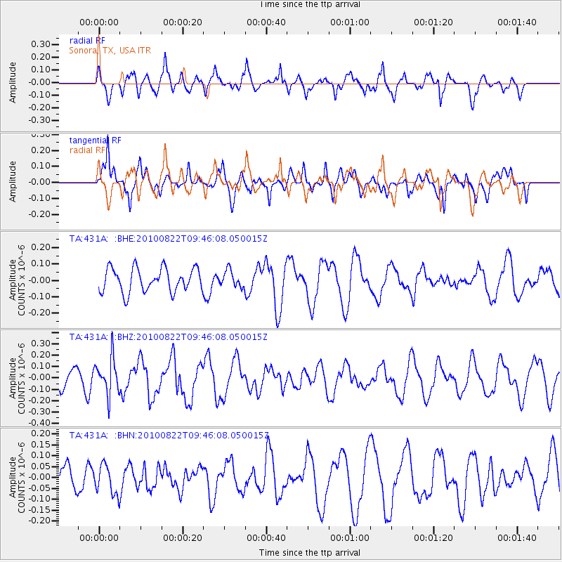
431A Sonora, TX, USA - Earthquake Result Viewer
*The percent match for this event was below the threshold and hence no stack was calculated.
| Earthquake location: |
Mariana Islands Region |
| Earthquake latitude/longitude: |
19.4/147.4 |
| Earthquake time(UTC): |
2010/08/22 (234) 09:33:06 GMT |
| Earthquake Depth: |
23 km |
| Earthquake Magnitude: |
5.9 MB, 5.3 MS, 5.5 MW |
| Earthquake Catalog/Contributor: |
WHDF/NEIC |
|
| Network: |
TA USArray Transportable Network (new EarthScope stations) |
| Station: |
431A Sonora, TX, USA |
| Lat/Lon: |
30.68 N/100.61 W |
| Elevation: |
700 m |
|
| Distance: |
97.9 deg |
| Az: |
53.733 deg |
| Baz: |
297.971 deg |
| Ray Param: |
$rayparam |
*The percent match for this event was below the threshold and hence was not used in the summary stack. |
|
| Radial Match: |
71.62683 % |
| Radial Bump: |
400 |
| Transverse Match: |
75.30459 % |
| Transverse Bump: |
400 |
| SOD ConfigId: |
319893 |
| Insert Time: |
2011-01-06 01:31:28.999 +0000 |
| GWidth: |
2.5 |
| Max Bumps: |
400 |
| Tol: |
0.001 |
|
Signal To Noise
| Channel | StoN | STA | LTA |
| TA:431A: :BHZ:20100822T09:46:08.050015Z | 2.4733407 | 1.6116438E-7 | 6.51606E-8 |
| TA:431A: :BHN:20100822T09:46:08.050015Z | 0.8693288 | 6.8493165E-8 | 7.878857E-8 |
| TA:431A: :BHE:20100822T09:46:08.050015Z | 0.71886796 | 5.163641E-8 | 7.183017E-8 |
| Arrivals |
| Ps | |
| PpPs | |
| PsPs/PpSs | |


