You are here: Home > Network List > GS - US Geological Survey Networks Stations List
> Station OK029 Liberty Lake, Oklahoma, USA > Earthquake Result Viewer
OK029 Liberty Lake, Oklahoma, USA - Earthquake Result Viewer
| Earthquake location: |
Central Bolivia |
| Earthquake latitude/longitude: |
-17.9/-65.9 |
| Earthquake time(UTC): |
2019/03/15 (074) 05:03:50 GMT |
| Earthquake Depth: |
358 km |
| Earthquake Magnitude: |
6.3 Mww |
| Earthquake Catalog/Contributor: |
NEIC PDE/us |
|
| Network: |
GS US Geological Survey Networks |
| Station: |
OK029 Liberty Lake, Oklahoma, USA |
| Lat/Lon: |
35.80 N/97.45 W |
| Elevation: |
333 m |
|
| Distance: |
61.2 deg |
| Az: |
330.938 deg |
| Baz: |
145.313 deg |
| Ray Param: |
0.05982062 |
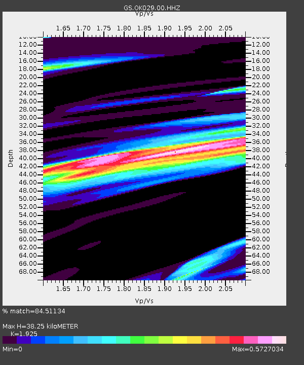
| Estimated Moho Depth: |
38.25 km |
| Estimated Crust Vp/Vs: |
1.92 |
| Assumed Crust Vp: |
6.426 km/s |
| Estimated Crust Vs: |
3.338 km/s |
| Estimated Crust Poisson's Ratio: |
0.32 |
|
| Radial Match: |
84.51134 % |
| Radial Bump: |
400 |
| Transverse Match: |
59.613064 % |
| Transverse Bump: |
400 |
| SOD ConfigId: |
3338192 |
| Insert Time: |
2019-03-29 05:20:07.254 +0000 |
| GWidth: |
2.5 |
| Max Bumps: |
400 |
| Tol: |
0.001 |
|

Signal To Noise
| Channel | StoN | STA | LTA |
| GS:OK029:00:HHZ:20190315T05:12:57.079023Z | 25.2883 | 3.0471288E-6 | 1.204956E-7 |
| GS:OK029:00:HH1:20190315T05:12:57.079023Z | 3.39706 | 7.293966E-7 | 2.1471408E-7 |
| GS:OK029:00:HH2:20190315T05:12:57.079023Z | 2.8640058 | 7.091886E-7 | 2.4762124E-7 |
| Arrivals |
| Ps | 5.7 SECOND |
| PpPs | 17 SECOND |
| PsPs/PpSs | 22 SECOND |


