You are here: Home > Network List > GS - US Geological Survey Networks Stations List
> Station ASA4 ASA4 > Earthquake Result Viewer
ASA4 ASA4 - Earthquake Result Viewer
| Earthquake location: |
Near West Coast Of Honshu, Japan |
| Earthquake latitude/longitude: |
37.5/137.2 |
| Earthquake time(UTC): |
2024/01/01 (001) 07:10:10 GMT |
| Earthquake Depth: |
0.0 km |
| Earthquake Magnitude: |
7.4 Mi |
| Earthquake Catalog/Contributor: |
NEIC PDE/pt |
|
| Network: |
GS US Geological Survey Networks |
| Station: |
ASA4 ASA4 |
| Lat/Lon: |
34.94 N/106.46 W |
| Elevation: |
1820 m |
|
| Distance: |
86.8 deg |
| Az: |
47.51 deg |
| Baz: |
314.449 deg |
| Ray Param: |
0.043805473 |
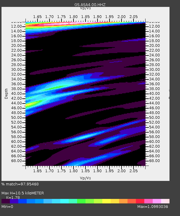
| Estimated Moho Depth: |
10.5 km |
| Estimated Crust Vp/Vs: |
1.78 |
| Assumed Crust Vp: |
6.502 km/s |
| Estimated Crust Vs: |
3.653 km/s |
| Estimated Crust Poisson's Ratio: |
0.27 |
|
| Radial Match: |
97.95468 % |
| Radial Bump: |
277 |
| Transverse Match: |
85.74743 % |
| Transverse Bump: |
400 |
| SOD ConfigId: |
33437571 |
| Insert Time: |
2024-01-15 07:55:02.649 +0000 |
| GWidth: |
2.5 |
| Max Bumps: |
400 |
| Tol: |
0.001 |
|

Signal To Noise
| Channel | StoN | STA | LTA |
| GS:ASA4:00:HHZ:20240101T07:22:24.559998Z | 3.9784331 | 9.846331E-7 | 2.4749266E-7 |
| GS:ASA4:00:HH1:20240101T07:22:24.559998Z | 1.8863208 | 3.6640768E-7 | 1.9424463E-7 |
| GS:ASA4:00:HH2:20240101T07:22:24.559998Z | 2.9267933 | 4.237739E-7 | 1.447912E-7 |
| Arrivals |
| Ps | 1.3 SECOND |
| PpPs | 4.4 SECOND |
| PsPs/PpSs | 5.7 SECOND |


