You are here: Home > Network List > II - Global Seismograph Network (GSN - IRIS/IDA) Stations List
> Station COCO West Island, Cocos (Keeling) Islands > Earthquake Result Viewer
COCO West Island, Cocos (Keeling) Islands - Earthquake Result Viewer
| Earthquake location: |
Near West Coast Of Honshu, Japan |
| Earthquake latitude/longitude: |
37.5/137.2 |
| Earthquake time(UTC): |
2024/01/01 (001) 07:10:10 GMT |
| Earthquake Depth: |
0.0 km |
| Earthquake Magnitude: |
7.4 Mi |
| Earthquake Catalog/Contributor: |
NEIC PDE/pt |
|
| Network: |
II Global Seismograph Network (GSN - IRIS/IDA) |
| Station: |
COCO West Island, Cocos (Keeling) Islands |
| Lat/Lon: |
12.19 S/96.83 E |
| Elevation: |
1.0 m |
|
| Distance: |
62.3 deg |
| Az: |
225.677 deg |
| Baz: |
35.587 deg |
| Ray Param: |
0.060364306 |
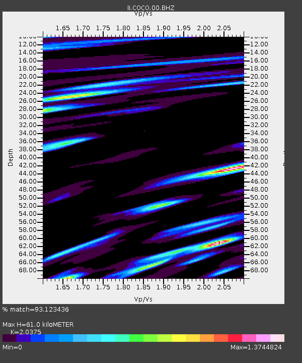
| Estimated Moho Depth: |
61.0 km |
| Estimated Crust Vp/Vs: |
2.04 |
| Assumed Crust Vp: |
4.24 km/s |
| Estimated Crust Vs: |
2.081 km/s |
| Estimated Crust Poisson's Ratio: |
0.34 |
|
| Radial Match: |
93.123436 % |
| Radial Bump: |
400 |
| Transverse Match: |
91.02336 % |
| Transverse Bump: |
400 |
| SOD ConfigId: |
33437571 |
| Insert Time: |
2024-01-15 07:56:07.189 +0000 |
| GWidth: |
2.5 |
| Max Bumps: |
400 |
| Tol: |
0.001 |
|
Signal To Noise
| Channel | StoN | STA | LTA |
| II:COCO:00:BHZ:20240101T07:20:02.544006Z | 2.0077245 | 2.124213E-6 | 1.0580203E-6 |
| II:COCO:00:BH1:20240101T07:20:02.544006Z | 0.6705429 | 1.4286063E-6 | 2.1305218E-6 |
| II:COCO:00:BH2:20240101T07:20:02.544006Z | 1.6164844 | 1.921641E-6 | 1.1887779E-6 |
| Arrivals |
| Ps | 15 SECOND |
| PpPs | 43 SECOND |
| PsPs/PpSs | 58 SECOND |


