You are here: Home > Network List > II - Global Seismograph Network (GSN - IRIS/IDA) Stations List
> Station KURK Kurchatov, Kazakhstan > Earthquake Result Viewer
KURK Kurchatov, Kazakhstan - Earthquake Result Viewer

| Earthquake location: |
Near West Coast Of Honshu, Japan |
| Earthquake latitude/longitude: |
37.5/137.2 |
| Earthquake time(UTC): |
2024/01/01 (001) 07:10:10 GMT |
| Earthquake Depth: |
0.0 km |
| Earthquake Magnitude: |
7.4 Mi |
| Earthquake Catalog/Contributor: |
NEIC PDE/pt |
|
| Network: |
II Global Seismograph Network (GSN - IRIS/IDA) |
| Station: |
KURK Kurchatov, Kazakhstan |
| Lat/Lon: |
50.72 N/78.62 E |
| Elevation: |
184 m |
|
| Distance: |
43.0 deg |
| Az: |
307.284 deg |
| Baz: |
84.503 deg |
| Ray Param: |
0.07286883 |
| Estimated Moho Depth: |
40.5 km |
| Estimated Crust Vp/Vs: |
1.79 |
| Assumed Crust Vp: |
6.552 km/s |
| Estimated Crust Vs: |
3.655 km/s |
| Estimated Crust Poisson's Ratio: |
0.27 |
|
| Radial Match: |
98.64118 % |
| Radial Bump: |
205 |
| Transverse Match: |
93.15372 % |
| Transverse Bump: |
400 |
| SOD ConfigId: |
33437571 |
| Insert Time: |
2024-01-15 07:56:11.208 +0000 |
| GWidth: |
2.5 |
| Max Bumps: |
400 |
| Tol: |
0.001 |
|
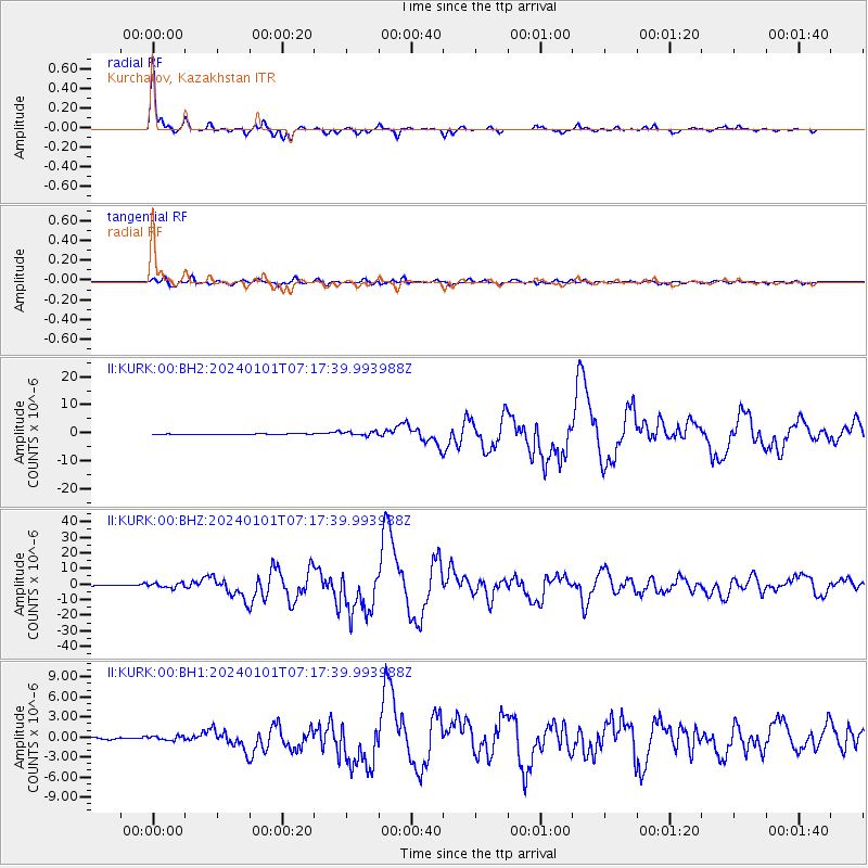
Signal To Noise
| Channel | StoN | STA | LTA |
| II:KURK:00:BHZ:20240101T07:17:39.993988Z | 10.667883 | 1.5040819E-6 | 1.409916E-7 |
| II:KURK:00:BH1:20240101T07:17:39.993988Z | 2.9035258 | 3.4487817E-7 | 1.187791E-7 |
| II:KURK:00:BH2:20240101T07:17:39.993988Z | 7.0339584 | 7.1741704E-7 | 1.0199336E-7 |
| Arrivals |
| Ps | 5.2 SECOND |
| PpPs | 16 SECOND |
| PsPs/PpSs | 21 SECOND |


