You are here: Home > Network List > IU - Global Seismograph Network (GSN - IRIS/USGS) Stations List
> Station GRFO Grafenberg, Germany > Earthquake Result Viewer
GRFO Grafenberg, Germany - Earthquake Result Viewer

| Earthquake location: |
Near West Coast Of Honshu, Japan |
| Earthquake latitude/longitude: |
37.5/137.2 |
| Earthquake time(UTC): |
2024/01/01 (001) 07:10:10 GMT |
| Earthquake Depth: |
0.0 km |
| Earthquake Magnitude: |
7.4 Mi |
| Earthquake Catalog/Contributor: |
NEIC PDE/pt |
|
| Network: |
IU Global Seismograph Network (GSN - IRIS/USGS) |
| Station: |
GRFO Grafenberg, Germany |
| Lat/Lon: |
49.69 N/11.22 E |
| Elevation: |
384 m |
|
| Distance: |
80.9 deg |
| Az: |
327.847 deg |
| Baz: |
40.672 deg |
| Ray Param: |
0.047955833 |
| Estimated Moho Depth: |
29.5 km |
| Estimated Crust Vp/Vs: |
1.92 |
| Assumed Crust Vp: |
6.182 km/s |
| Estimated Crust Vs: |
3.212 km/s |
| Estimated Crust Poisson's Ratio: |
0.32 |
|
| Radial Match: |
96.34232 % |
| Radial Bump: |
368 |
| Transverse Match: |
90.754135 % |
| Transverse Bump: |
400 |
| SOD ConfigId: |
33437571 |
| Insert Time: |
2024-01-15 07:56:58.290 +0000 |
| GWidth: |
2.5 |
| Max Bumps: |
400 |
| Tol: |
0.001 |
|
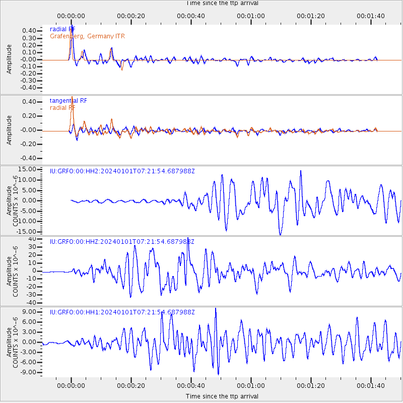
Signal To Noise
| Channel | StoN | STA | LTA |
| IU:GRFO:00:HHZ:20240101T07:21:54.687988Z | 7.213457 | 2.3640425E-6 | 3.277267E-7 |
| IU:GRFO:00:HH1:20240101T07:21:54.687988Z | 1.4017221 | 6.1751695E-7 | 4.4054167E-7 |
| IU:GRFO:00:HH2:20240101T07:21:54.687988Z | 1.334824 | 6.3272887E-7 | 4.7401673E-7 |
| Arrivals |
| Ps | 4.5 SECOND |
| PpPs | 14 SECOND |
| PsPs/PpSs | 18 SECOND |


