You are here: Home > Network List > IW - Intermountain West Stations List
> Station PLID Pearl Lake, Idaho, USA > Earthquake Result Viewer
PLID Pearl Lake, Idaho, USA - Earthquake Result Viewer
| Earthquake location: |
Near West Coast Of Honshu, Japan |
| Earthquake latitude/longitude: |
37.5/137.2 |
| Earthquake time(UTC): |
2024/01/01 (001) 07:10:10 GMT |
| Earthquake Depth: |
0.0 km |
| Earthquake Magnitude: |
7.4 Mi |
| Earthquake Catalog/Contributor: |
NEIC PDE/pt |
|
| Network: |
IW Intermountain West |
| Station: |
PLID Pearl Lake, Idaho, USA |
| Lat/Lon: |
45.09 N/116.00 W |
| Elevation: |
2164 m |
|
| Distance: |
74.6 deg |
| Az: |
44.693 deg |
| Baz: |
307.851 deg |
| Ray Param: |
0.052230984 |
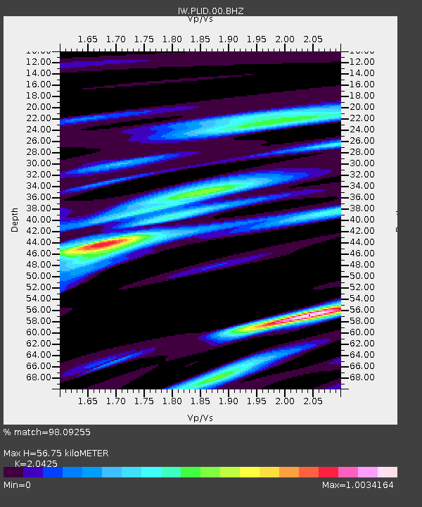
| Estimated Moho Depth: |
56.75 km |
| Estimated Crust Vp/Vs: |
2.04 |
| Assumed Crust Vp: |
6.571 km/s |
| Estimated Crust Vs: |
3.217 km/s |
| Estimated Crust Poisson's Ratio: |
0.34 |
|
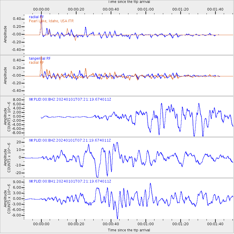
| Radial Match: |
98.09255 % |
| Radial Bump: |
400 |
| Transverse Match: |
93.99131 % |
| Transverse Bump: |
400 |
| SOD ConfigId: |
33437571 |
| Insert Time: |
2024-01-15 07:57:24.892 +0000 |
| GWidth: |
2.5 |
| Max Bumps: |
400 |
| Tol: |
0.001 |
|
Signal To Noise
| Channel | StoN | STA | LTA |
| IW:PLID:00:BHZ:20240101T07:21:19.674011Z | 8.250149 | 1.2497154E-6 | 1.5147792E-7 |
| IW:PLID:00:BH1:20240101T07:21:19.674011Z | 2.5164287 | 3.7094978E-7 | 1.474112E-7 |
| IW:PLID:00:BH2:20240101T07:21:19.674011Z | 2.206592 | 4.1483415E-7 | 1.8799766E-7 |
| Arrivals |
| Ps | 9.3 SECOND |
| PpPs | 26 SECOND |
| PsPs/PpSs | 35 SECOND |


