You are here: Home > Network List > KR - Kyrgyz Digital Network Stations List
> Station BOOM Boom, Kyrgyzstan > Earthquake Result Viewer
BOOM Boom, Kyrgyzstan - Earthquake Result Viewer

| Earthquake location: |
Near West Coast Of Honshu, Japan |
| Earthquake latitude/longitude: |
37.5/137.2 |
| Earthquake time(UTC): |
2024/01/01 (001) 07:10:10 GMT |
| Earthquake Depth: |
0.0 km |
| Earthquake Magnitude: |
7.4 Mi |
| Earthquake Catalog/Contributor: |
NEIC PDE/pt |
|
| Network: |
KR Kyrgyz Digital Network |
| Station: |
BOOM Boom, Kyrgyzstan |
| Lat/Lon: |
42.49 N/75.94 E |
| Elevation: |
1737 m |
|
| Distance: |
46.3 deg |
| Az: |
296.238 deg |
| Baz: |
74.683 deg |
| Ray Param: |
0.0707676 |
| Estimated Moho Depth: |
65.75 km |
| Estimated Crust Vp/Vs: |
1.79 |
| Assumed Crust Vp: |
6.306 km/s |
| Estimated Crust Vs: |
3.533 km/s |
| Estimated Crust Poisson's Ratio: |
0.27 |
|
| Radial Match: |
96.63526 % |
| Radial Bump: |
299 |
| Transverse Match: |
91.95911 % |
| Transverse Bump: |
400 |
| SOD ConfigId: |
33437571 |
| Insert Time: |
2024-01-15 07:57:48.587 +0000 |
| GWidth: |
2.5 |
| Max Bumps: |
400 |
| Tol: |
0.001 |
|
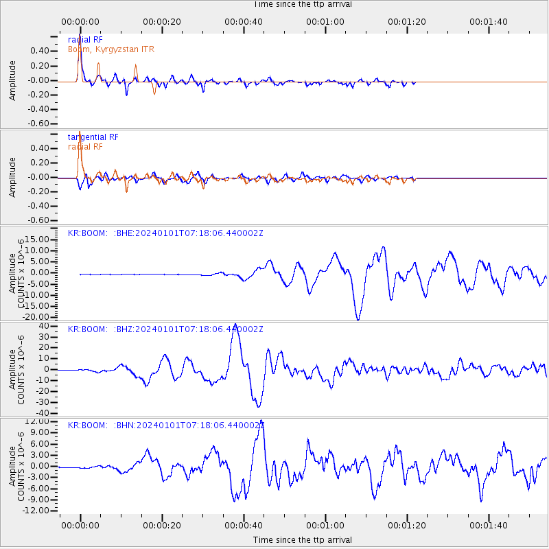
Signal To Noise
| Channel | StoN | STA | LTA |
| KR:BOOM: :BHZ:20240101T07:18:06.440002Z | 9.353647 | 9.949996E-7 | 1.06375566E-7 |
| KR:BOOM: :BHN:20240101T07:18:06.440002Z | 2.7159605 | 2.433995E-7 | 8.961821E-8 |
| KR:BOOM: :BHE:20240101T07:18:06.440002Z | 5.1088357 | 4.811992E-7 | 9.418961E-8 |
| Arrivals |
| Ps | 8.7 SECOND |
| PpPs | 27 SECOND |
| PsPs/PpSs | 36 SECOND |


