You are here: Home > Network List > MB - Montana Regional Seismic Network Stations List
> Station BUT Butte, Montana > Earthquake Result Viewer
BUT Butte, Montana - Earthquake Result Viewer
| Earthquake location: |
Near West Coast Of Honshu, Japan |
| Earthquake latitude/longitude: |
37.5/137.2 |
| Earthquake time(UTC): |
2024/01/01 (001) 07:10:10 GMT |
| Earthquake Depth: |
0.0 km |
| Earthquake Magnitude: |
7.4 Mi |
| Earthquake Catalog/Contributor: |
NEIC PDE/pt |
|
| Network: |
MB Montana Regional Seismic Network |
| Station: |
BUT Butte, Montana |
| Lat/Lon: |
46.01 N/112.56 W |
| Elevation: |
1758 m |
|
| Distance: |
75.9 deg |
| Az: |
42.383 deg |
| Baz: |
309.714 deg |
| Ray Param: |
0.051353958 |
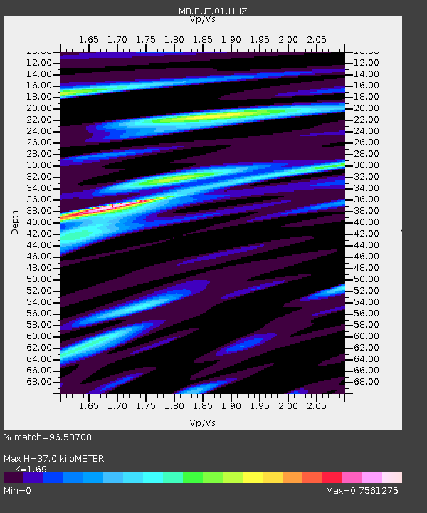
| Estimated Moho Depth: |
37.0 km |
| Estimated Crust Vp/Vs: |
1.69 |
| Assumed Crust Vp: |
6.353 km/s |
| Estimated Crust Vs: |
3.759 km/s |
| Estimated Crust Poisson's Ratio: |
0.23 |
|
| Radial Match: |
96.58708 % |
| Radial Bump: |
307 |
| Transverse Match: |
87.81781 % |
| Transverse Bump: |
400 |
| SOD ConfigId: |
33437571 |
| Insert Time: |
2024-01-15 07:58:35.459 +0000 |
| GWidth: |
2.5 |
| Max Bumps: |
400 |
| Tol: |
0.001 |
|

Signal To Noise
| Channel | StoN | STA | LTA |
| MB:BUT:01:HHZ:20240101T07:21:27.179993Z | 7.3436337 | 3.0592437E-6 | 4.1658447E-7 |
| MB:BUT:01:HHN:20240101T07:21:27.179993Z | 3.5090947 | 1.1061343E-6 | 3.1521924E-7 |
| MB:BUT:01:HHE:20240101T07:21:27.179993Z | 2.8154855 | 1.6872488E-6 | 5.9927453E-7 |
| Arrivals |
| Ps | 4.2 SECOND |
| PpPs | 15 SECOND |
| PsPs/PpSs | 19 SECOND |


