You are here: Home > Network List > MB - Montana Regional Seismic Network Stations List
> Station ECMT Emigrant Creek, MT > Earthquake Result Viewer
ECMT Emigrant Creek, MT - Earthquake Result Viewer
| Earthquake location: |
Near West Coast Of Honshu, Japan |
| Earthquake latitude/longitude: |
37.5/137.2 |
| Earthquake time(UTC): |
2024/01/01 (001) 07:10:10 GMT |
| Earthquake Depth: |
0.0 km |
| Earthquake Magnitude: |
7.4 Mi |
| Earthquake Catalog/Contributor: |
NEIC PDE/pt |
|
| Network: |
MB Montana Regional Seismic Network |
| Station: |
ECMT Emigrant Creek, MT |
| Lat/Lon: |
45.32 N/110.74 W |
| Elevation: |
1567 m |
|
| Distance: |
77.4 deg |
| Az: |
42.076 deg |
| Baz: |
310.939 deg |
| Ray Param: |
0.050396323 |
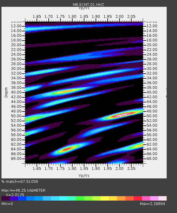
| Estimated Moho Depth: |
49.25 km |
| Estimated Crust Vp/Vs: |
2.01 |
| Assumed Crust Vp: |
6.35 km/s |
| Estimated Crust Vs: |
3.155 km/s |
| Estimated Crust Poisson's Ratio: |
0.34 |
|
| Radial Match: |
87.51059 % |
| Radial Bump: |
400 |
| Transverse Match: |
77.13182 % |
| Transverse Bump: |
400 |
| SOD ConfigId: |
33437571 |
| Insert Time: |
2024-01-15 07:58:45.861 +0000 |
| GWidth: |
2.5 |
| Max Bumps: |
400 |
| Tol: |
0.001 |
|

Signal To Noise
| Channel | StoN | STA | LTA |
| MB:ECMT:01:HHZ:20240101T07:21:35.169983Z | 6.173458 | 5.0973044E-6 | 8.256806E-7 |
| MB:ECMT:01:HHN:20240101T07:21:35.169983Z | 1.9137403 | 2.1318328E-6 | 1.1139614E-6 |
| MB:ECMT:01:HHE:20240101T07:21:35.169983Z | 1.6599017 | 2.0529433E-6 | 1.236786E-6 |
| Arrivals |
| Ps | 8.1 SECOND |
| PpPs | 23 SECOND |
| PsPs/PpSs | 31 SECOND |


