You are here: Home > Network List > TA - USArray Transportable Network (new EarthScope stations) Stations List
> Station Q29A Oakley, KS, USA > Earthquake Result Viewer
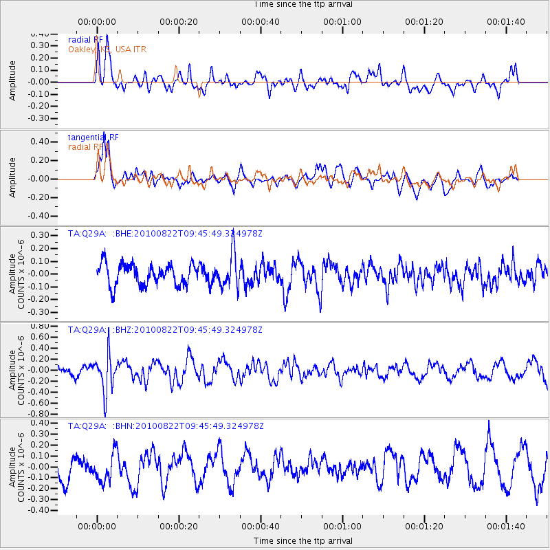
Q29A Oakley, KS, USA - Earthquake Result Viewer
*The percent match for this event was below the threshold and hence no stack was calculated.
| Earthquake location: |
Mariana Islands Region |
| Earthquake latitude/longitude: |
19.4/147.4 |
| Earthquake time(UTC): |
2010/08/22 (234) 09:33:06 GMT |
| Earthquake Depth: |
23 km |
| Earthquake Magnitude: |
5.9 MB, 5.3 MS, 5.5 MW |
| Earthquake Catalog/Contributor: |
WHDF/NEIC |
|
| Network: |
TA USArray Transportable Network (new EarthScope stations) |
| Station: |
Q29A Oakley, KS, USA |
| Lat/Lon: |
38.89 N/100.98 W |
| Elevation: |
895 m |
|
| Distance: |
93.7 deg |
| Az: |
46.628 deg |
| Baz: |
298.478 deg |
| Ray Param: |
$rayparam |
*The percent match for this event was below the threshold and hence was not used in the summary stack. |
|
| Radial Match: |
74.27655 % |
| Radial Bump: |
400 |
| Transverse Match: |
86.15593 % |
| Transverse Bump: |
400 |
| SOD ConfigId: |
319893 |
| Insert Time: |
2011-01-06 01:33:53.399 +0000 |
| GWidth: |
2.5 |
| Max Bumps: |
400 |
| Tol: |
0.001 |
|
Signal To Noise
| Channel | StoN | STA | LTA |
| TA:Q29A: :BHZ:20100822T09:45:49.324978Z | 5.159716 | 3.3673888E-7 | 6.5263066E-8 |
| TA:Q29A: :BHN:20100822T09:45:49.324978Z | 1.4892261 | 1.4130555E-7 | 9.4885216E-8 |
| TA:Q29A: :BHE:20100822T09:45:49.324978Z | 1.6336844 | 1.3352565E-7 | 8.173282E-8 |
| Arrivals |
| Ps | |
| PpPs | |
| PsPs/PpSs | |


