You are here: Home > Network List > N4 - Central and EAstern US Network Stations List
> Station Q54A Coxs Mills, WV, USA > Earthquake Result Viewer
Q54A Coxs Mills, WV, USA - Earthquake Result Viewer
| Earthquake location: |
Near West Coast Of Honshu, Japan |
| Earthquake latitude/longitude: |
37.5/137.2 |
| Earthquake time(UTC): |
2024/01/01 (001) 07:10:10 GMT |
| Earthquake Depth: |
0.0 km |
| Earthquake Magnitude: |
7.4 Mi |
| Earthquake Catalog/Contributor: |
NEIC PDE/pt |
|
| Network: |
N4 Central and EAstern US Network |
| Station: |
Q54A Coxs Mills, WV, USA |
| Lat/Lon: |
38.98 N/80.83 W |
| Elevation: |
254 m |
|
| Distance: |
96.2 deg |
| Az: |
28.885 deg |
| Baz: |
330.467 deg |
| Ray Param: |
0.040583316 |
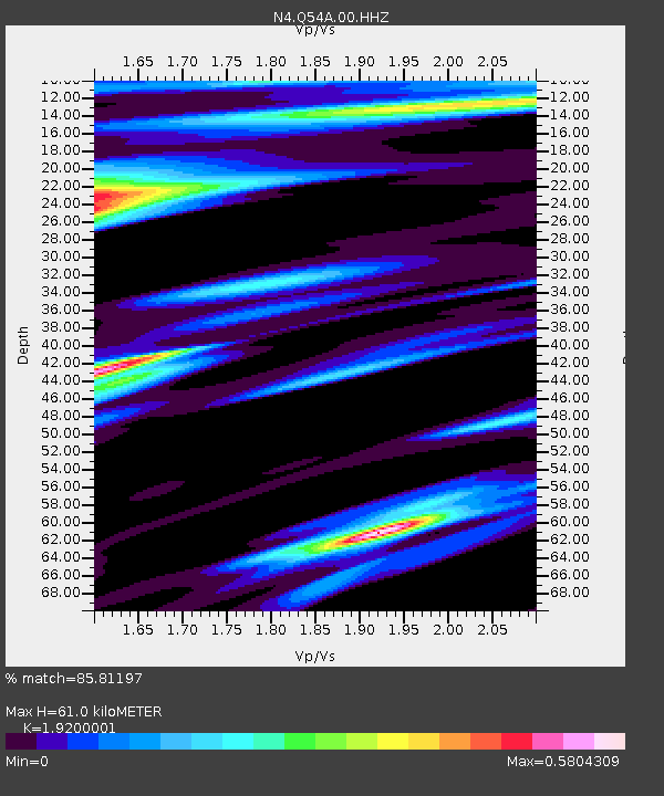
| Estimated Moho Depth: |
61.0 km |
| Estimated Crust Vp/Vs: |
1.92 |
| Assumed Crust Vp: |
6.207 km/s |
| Estimated Crust Vs: |
3.233 km/s |
| Estimated Crust Poisson's Ratio: |
0.31 |
|
| Radial Match: |
85.81197 % |
| Radial Bump: |
400 |
| Transverse Match: |
67.61805 % |
| Transverse Bump: |
400 |
| SOD ConfigId: |
33437571 |
| Insert Time: |
2024-01-15 08:00:09.078 +0000 |
| GWidth: |
2.5 |
| Max Bumps: |
400 |
| Tol: |
0.001 |
|

Signal To Noise
| Channel | StoN | STA | LTA |
| N4:Q54A:00:HHZ:20240101T07:23:08.208984Z | 2.079091 | 1.3454832E-6 | 6.4714965E-7 |
| N4:Q54A:00:HH1:20240101T07:23:08.208984Z | 1.1975975 | 6.377838E-7 | 5.325527E-7 |
| N4:Q54A:00:HH2:20240101T07:23:08.208984Z | 0.6522142 | 2.7088768E-7 | 4.1533542E-7 |
| Arrivals |
| Ps | 9.2 SECOND |
| PpPs | 28 SECOND |
| PsPs/PpSs | 37 SECOND |


