You are here: Home > Network List > TA - USArray Transportable Network (new EarthScope stations) Stations List
> Station P31A Stockton, KS, USA > Earthquake Result Viewer
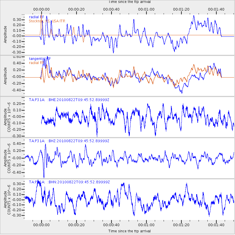
P31A Stockton, KS, USA - Earthquake Result Viewer
*The percent match for this event was below the threshold and hence no stack was calculated.
| Earthquake location: |
Mariana Islands Region |
| Earthquake latitude/longitude: |
19.4/147.4 |
| Earthquake time(UTC): |
2010/08/22 (234) 09:33:06 GMT |
| Earthquake Depth: |
23 km |
| Earthquake Magnitude: |
5.9 MB, 5.3 MS, 5.5 MW |
| Earthquake Catalog/Contributor: |
WHDF/NEIC |
|
| Network: |
TA USArray Transportable Network (new EarthScope stations) |
| Station: |
P31A Stockton, KS, USA |
| Lat/Lon: |
39.52 N/99.38 W |
| Elevation: |
665 m |
|
| Distance: |
94.5 deg |
| Az: |
45.471 deg |
| Baz: |
299.568 deg |
| Ray Param: |
$rayparam |
*The percent match for this event was below the threshold and hence was not used in the summary stack. |
|
| Radial Match: |
49.60089 % |
| Radial Bump: |
400 |
| Transverse Match: |
62.934536 % |
| Transverse Bump: |
400 |
| SOD ConfigId: |
319893 |
| Insert Time: |
2011-01-06 01:34:30.070 +0000 |
| GWidth: |
2.5 |
| Max Bumps: |
400 |
| Tol: |
0.001 |
|
Signal To Noise
| Channel | StoN | STA | LTA |
| TA:P31A: :BHZ:20100822T09:45:52.89999Z | 2.8382642 | 2.1680844E-7 | 7.638769E-8 |
| TA:P31A: :BHN:20100822T09:45:52.89999Z | 1.2234378 | 1.6997765E-7 | 1.3893445E-7 |
| TA:P31A: :BHE:20100822T09:45:52.89999Z | 1.7673808 | 1.066229E-7 | 6.03282E-8 |
| Arrivals |
| Ps | |
| PpPs | |
| PsPs/PpSs | |


