You are here: Home > Network List > TA - USArray Transportable Network (new EarthScope stations) Stations List
> Station H28A Mission Ridge, SD, USA > Earthquake Result Viewer
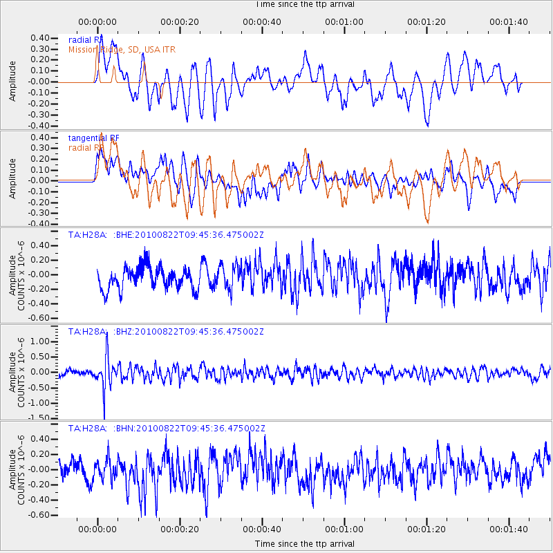
H28A Mission Ridge, SD, USA - Earthquake Result Viewer
*The percent match for this event was below the threshold and hence no stack was calculated.
| Earthquake location: |
Mariana Islands Region |
| Earthquake latitude/longitude: |
19.4/147.4 |
| Earthquake time(UTC): |
2010/08/22 (234) 09:33:06 GMT |
| Earthquake Depth: |
23 km |
| Earthquake Magnitude: |
5.9 MB, 5.3 MS, 5.5 MW |
| Earthquake Catalog/Contributor: |
WHDF/NEIC |
|
| Network: |
TA USArray Transportable Network (new EarthScope stations) |
| Station: |
H28A Mission Ridge, SD, USA |
| Lat/Lon: |
44.68 N/101.02 W |
| Elevation: |
642 m |
|
| Distance: |
90.9 deg |
| Az: |
41.563 deg |
| Baz: |
298.655 deg |
| Ray Param: |
$rayparam |
*The percent match for this event was below the threshold and hence was not used in the summary stack. |
|
| Radial Match: |
63.036182 % |
| Radial Bump: |
400 |
| Transverse Match: |
52.684635 % |
| Transverse Bump: |
400 |
| SOD ConfigId: |
319893 |
| Insert Time: |
2011-01-06 01:35:50.368 +0000 |
| GWidth: |
2.5 |
| Max Bumps: |
400 |
| Tol: |
0.001 |
|
Signal To Noise
| Channel | StoN | STA | LTA |
| TA:H28A: :BHZ:20100822T09:45:36.475002Z | 5.9441576 | 5.0678824E-7 | 8.525821E-8 |
| TA:H28A: :BHN:20100822T09:45:36.475002Z | 0.7690309 | 1.2502801E-7 | 1.6257864E-7 |
| TA:H28A: :BHE:20100822T09:45:36.475002Z | 1.1232715 | 1.6550159E-7 | 1.4733891E-7 |
| Arrivals |
| Ps | |
| PpPs | |
| PsPs/PpSs | |


