You are here: Home > Network List > RV - Regional Alberta Seismic Observatory for Earthquake Studies Network Stations List
> Station PECRA Peace River, AB > Earthquake Result Viewer
PECRA Peace River, AB - Earthquake Result Viewer
| Earthquake location: |
Near West Coast Of Honshu, Japan |
| Earthquake latitude/longitude: |
37.5/137.2 |
| Earthquake time(UTC): |
2024/01/01 (001) 07:10:10 GMT |
| Earthquake Depth: |
0.0 km |
| Earthquake Magnitude: |
7.4 Mi |
| Earthquake Catalog/Contributor: |
NEIC PDE/pt |
|
| Network: |
RV Regional Alberta Seismic Observatory for Earthquake Studies Network |
| Station: |
PECRA Peace River, AB |
| Lat/Lon: |
56.30 N/117.03 W |
| Elevation: |
592 m |
|
| Distance: |
67.5 deg |
| Az: |
35.501 deg |
| Baz: |
304.06 deg |
| Ray Param: |
0.05695095 |
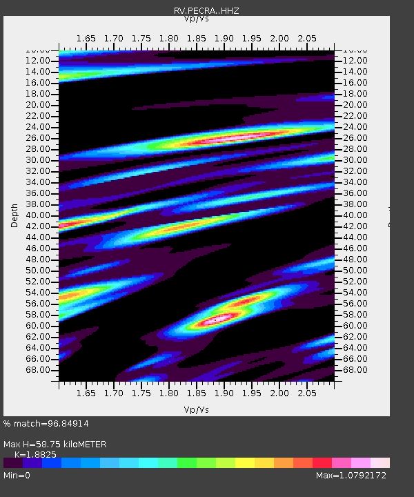
| Estimated Moho Depth: |
58.75 km |
| Estimated Crust Vp/Vs: |
1.88 |
| Assumed Crust Vp: |
6.444 km/s |
| Estimated Crust Vs: |
3.423 km/s |
| Estimated Crust Poisson's Ratio: |
0.30 |
|
| Radial Match: |
96.84914 % |
| Radial Bump: |
400 |
| Transverse Match: |
89.498024 % |
| Transverse Bump: |
400 |
| SOD ConfigId: |
33437571 |
| Insert Time: |
2024-01-15 08:05:49.145 +0000 |
| GWidth: |
2.5 |
| Max Bumps: |
400 |
| Tol: |
0.001 |
|

Signal To Noise
| Channel | StoN | STA | LTA |
| RV:PECRA: :HHZ:20240101T07:20:36.51001Z | 6.840316 | 1.7763675E-6 | 2.5969086E-7 |
| RV:PECRA: :HHN:20240101T07:20:36.51001Z | 1.238607 | 5.912362E-7 | 4.773396E-7 |
| RV:PECRA: :HHE:20240101T07:20:36.51001Z | 1.3096431 | 9.323838E-7 | 7.119372E-7 |
| Arrivals |
| Ps | 8.4 SECOND |
| PpPs | 25 SECOND |
| PsPs/PpSs | 34 SECOND |


