You are here: Home > Network List > RV - Regional Alberta Seismic Observatory for Earthquake Studies Network Stations List
> Station THORA Thorhild, AB > Earthquake Result Viewer
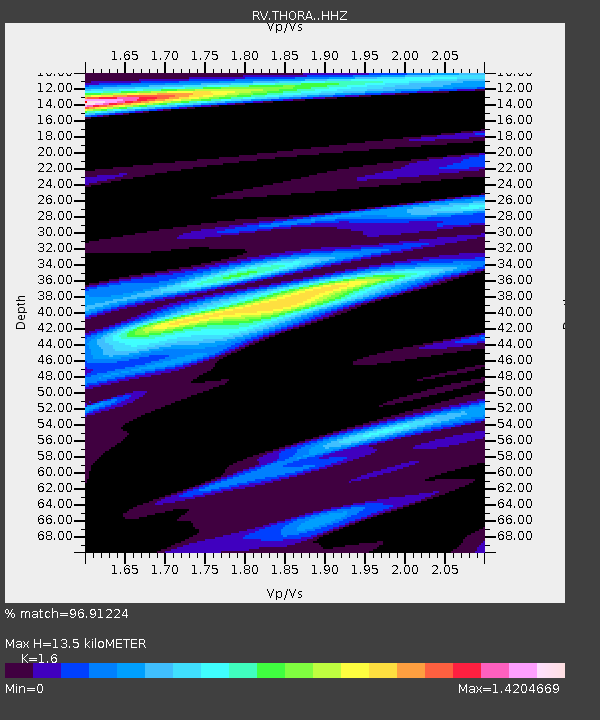
THORA Thorhild, AB - Earthquake Result Viewer
| Earthquake location: |
Near West Coast Of Honshu, Japan |
| Earthquake latitude/longitude: |
37.5/137.2 |
| Earthquake time(UTC): |
2024/01/01 (001) 07:10:10 GMT |
| Earthquake Depth: |
0.0 km |
| Earthquake Magnitude: |
7.4 Mi |
| Earthquake Catalog/Contributor: |
NEIC PDE/pt |
|
| Network: |
RV Regional Alberta Seismic Observatory for Earthquake Studies Network |
| Station: |
THORA Thorhild, AB |
| Lat/Lon: |
54.20 N/113.21 W |
| Elevation: |
640 m |
|
| Distance: |
70.5 deg |
| Az: |
35.958 deg |
| Baz: |
307.353 deg |
| Ray Param: |
0.054981355 |
| Estimated Moho Depth: |
13.5 km |
| Estimated Crust Vp/Vs: |
1.60 |
| Assumed Crust Vp: |
6.444 km/s |
| Estimated Crust Vs: |
4.027 km/s |
| Estimated Crust Poisson's Ratio: |
0.18 |
|
| Radial Match: |
96.91224 % |
| Radial Bump: |
329 |
| Transverse Match: |
92.07227 % |
| Transverse Bump: |
400 |
| SOD ConfigId: |
33437571 |
| Insert Time: |
2024-01-15 08:05:58.515 +0000 |
| GWidth: |
2.5 |
| Max Bumps: |
400 |
| Tol: |
0.001 |
|

Signal To Noise
| Channel | StoN | STA | LTA |
| RV:THORA: :HHZ:20240101T07:20:55.090027Z | 5.2879324 | 1.4992975E-6 | 2.8353188E-7 |
| RV:THORA: :HHN:20240101T07:20:55.090027Z | 1.2936498 | 8.4856293E-7 | 6.559449E-7 |
| RV:THORA: :HHE:20240101T07:20:55.090027Z | 1.7081709 | 9.4391487E-7 | 5.5258806E-7 |
| Arrivals |
| Ps | 1.3 SECOND |
| PpPs | 5.2 SECOND |
| PsPs/PpSs | 6.5 SECOND |


