You are here: Home > Network List > S1 - Australian Seismometers in Schools Stations List
> Station AUMBR Murray Bridge High School > Earthquake Result Viewer
AUMBR Murray Bridge High School - Earthquake Result Viewer
| Earthquake location: |
Near West Coast Of Honshu, Japan |
| Earthquake latitude/longitude: |
37.5/137.2 |
| Earthquake time(UTC): |
2024/01/01 (001) 07:10:10 GMT |
| Earthquake Depth: |
0.0 km |
| Earthquake Magnitude: |
7.4 Mi |
| Earthquake Catalog/Contributor: |
NEIC PDE/pt |
|
| Network: |
S1 Australian Seismometers in Schools |
| Station: |
AUMBR Murray Bridge High School |
| Lat/Lon: |
35.13 S/139.29 E |
| Elevation: |
50 m |
|
| Distance: |
72.3 deg |
| Az: |
178.205 deg |
| Baz: |
358.259 deg |
| Ray Param: |
0.053780705 |
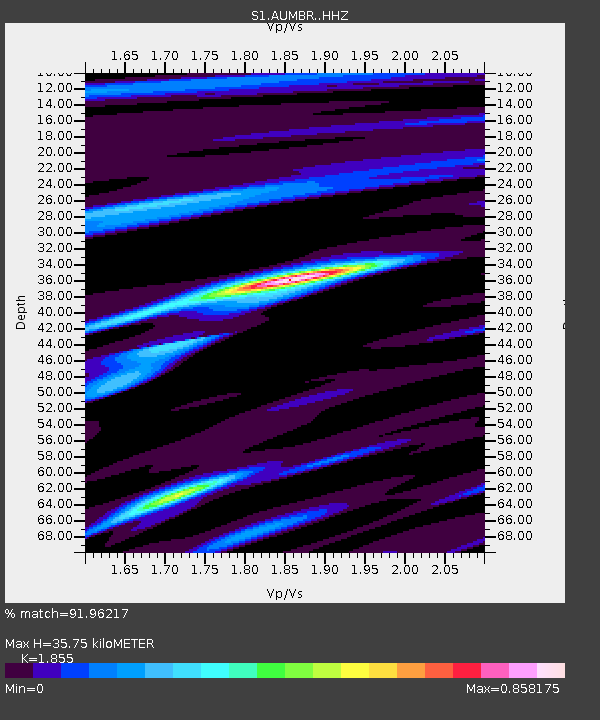
| Estimated Moho Depth: |
35.75 km |
| Estimated Crust Vp/Vs: |
1.86 |
| Assumed Crust Vp: |
6.576 km/s |
| Estimated Crust Vs: |
3.545 km/s |
| Estimated Crust Poisson's Ratio: |
0.30 |
|
| Radial Match: |
91.96217 % |
| Radial Bump: |
268 |
| Transverse Match: |
89.0983 % |
| Transverse Bump: |
400 |
| SOD ConfigId: |
33437571 |
| Insert Time: |
2024-01-15 08:06:20.048 +0000 |
| GWidth: |
2.5 |
| Max Bumps: |
400 |
| Tol: |
0.001 |
|

Signal To Noise
| Channel | StoN | STA | LTA |
| S1:AUMBR: :HHZ:20240101T07:21:05.929993Z | 3.9421809 | 6.841351E-7 | 1.735423E-7 |
| S1:AUMBR: :HHN:20240101T07:21:05.929993Z | 0.25878492 | 2.0280804E-7 | 7.836934E-7 |
| S1:AUMBR: :HHE:20240101T07:21:05.929993Z | 1.5193439 | 3.1153377E-7 | 2.0504494E-7 |
| Arrivals |
| Ps | 4.8 SECOND |
| PpPs | 15 SECOND |
| PsPs/PpSs | 20 SECOND |


