You are here: Home > Network List > TX - Texas Seismological Network Stations List
> Station MB03 TX-MB03 > Earthquake Result Viewer
MB03 TX-MB03 - Earthquake Result Viewer
| Earthquake location: |
Near West Coast Of Honshu, Japan |
| Earthquake latitude/longitude: |
37.5/137.2 |
| Earthquake time(UTC): |
2024/01/01 (001) 07:10:10 GMT |
| Earthquake Depth: |
0.0 km |
| Earthquake Magnitude: |
7.4 Mi |
| Earthquake Catalog/Contributor: |
NEIC PDE/pt |
|
| Network: |
TX Texas Seismological Network |
| Station: |
MB03 TX-MB03 |
| Lat/Lon: |
31.74 N/100.62 W |
| Elevation: |
734 m |
|
| Distance: |
92.5 deg |
| Az: |
46.2 deg |
| Baz: |
317.643 deg |
| Ray Param: |
0.04145201 |
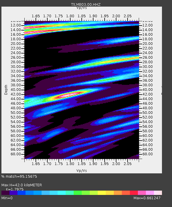
| Estimated Moho Depth: |
42.0 km |
| Estimated Crust Vp/Vs: |
1.80 |
| Assumed Crust Vp: |
6.38 km/s |
| Estimated Crust Vs: |
3.55 km/s |
| Estimated Crust Poisson's Ratio: |
0.28 |
|
| Radial Match: |
95.15675 % |
| Radial Bump: |
400 |
| Transverse Match: |
88.13622 % |
| Transverse Bump: |
400 |
| SOD ConfigId: |
33437571 |
| Insert Time: |
2024-01-15 08:08:38.761 +0000 |
| GWidth: |
2.5 |
| Max Bumps: |
400 |
| Tol: |
0.001 |
|

Signal To Noise
| Channel | StoN | STA | LTA |
| TX:MB03:00:HHZ:20240101T07:22:51.226013Z | 2.6516716 | 8.876634E-7 | 3.3475618E-7 |
| TX:MB03:00:HHN:20240101T07:22:51.226013Z | 2.1200514 | 5.0500324E-7 | 2.3820333E-7 |
| TX:MB03:00:HHE:20240101T07:22:51.226013Z | 2.1933663 | 6.723043E-7 | 3.065171E-7 |
| Arrivals |
| Ps | 5.4 SECOND |
| PpPs | 18 SECOND |
| PsPs/PpSs | 23 SECOND |


