You are here: Home > Network List > UO - University of Oregon Regional Network Stations List
> Station HBUG Ophir, OR, USA > Earthquake Result Viewer
HBUG Ophir, OR, USA - Earthquake Result Viewer
| Earthquake location: |
Near West Coast Of Honshu, Japan |
| Earthquake latitude/longitude: |
37.5/137.2 |
| Earthquake time(UTC): |
2024/01/01 (001) 07:10:10 GMT |
| Earthquake Depth: |
0.0 km |
| Earthquake Magnitude: |
7.4 Mi |
| Earthquake Catalog/Contributor: |
NEIC PDE/pt |
|
| Network: |
UO University of Oregon Regional Network |
| Station: |
HBUG Ophir, OR, USA |
| Lat/Lon: |
42.64 N/124.38 W |
| Elevation: |
388 m |
|
| Distance: |
71.1 deg |
| Az: |
50.472 deg |
| Baz: |
303.761 deg |
| Ray Param: |
0.05453591 |
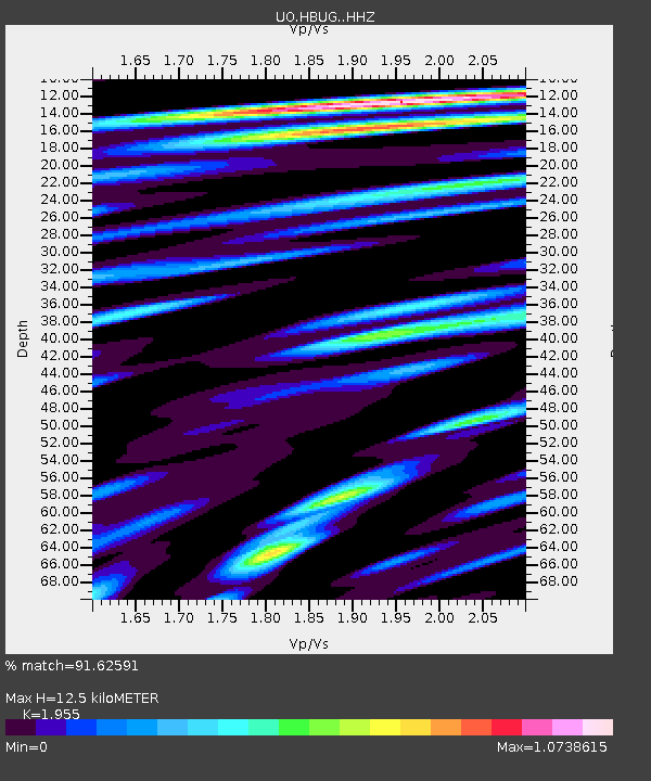
| Estimated Moho Depth: |
12.5 km |
| Estimated Crust Vp/Vs: |
1.96 |
| Assumed Crust Vp: |
6.048 km/s |
| Estimated Crust Vs: |
3.094 km/s |
| Estimated Crust Poisson's Ratio: |
0.32 |
|
| Radial Match: |
91.62591 % |
| Radial Bump: |
400 |
| Transverse Match: |
83.12143 % |
| Transverse Bump: |
400 |
| SOD ConfigId: |
33437571 |
| Insert Time: |
2024-01-15 08:09:45.298 +0000 |
| GWidth: |
2.5 |
| Max Bumps: |
400 |
| Tol: |
0.001 |
|

Signal To Noise
| Channel | StoN | STA | LTA |
| UO:HBUG: :HHZ:20240101T07:20:59.030029Z | 1.9720174 | 1.50901E-6 | 7.6521127E-7 |
| UO:HBUG: :HHN:20240101T07:20:59.030029Z | 1.8127806 | 8.7921694E-7 | 4.850101E-7 |
| UO:HBUG: :HHE:20240101T07:20:59.030029Z | 2.2385628 | 1.0537716E-6 | 4.7073576E-7 |
| Arrivals |
| Ps | 2.0 SECOND |
| PpPs | 5.9 SECOND |
| PsPs/PpSs | 8.0 SECOND |


