You are here: Home > Network List > UO - University of Oregon Regional Network Stations List
> Station NECAN Necanicum, OR, USA > Earthquake Result Viewer
NECAN Necanicum, OR, USA - Earthquake Result Viewer
| Earthquake location: |
Near West Coast Of Honshu, Japan |
| Earthquake latitude/longitude: |
37.5/137.2 |
| Earthquake time(UTC): |
2024/01/01 (001) 07:10:10 GMT |
| Earthquake Depth: |
0.0 km |
| Earthquake Magnitude: |
7.4 Mi |
| Earthquake Catalog/Contributor: |
NEIC PDE/pt |
|
| Network: |
UO University of Oregon Regional Network |
| Station: |
NECAN Necanicum, OR, USA |
| Lat/Lon: |
45.87 N/123.82 W |
| Elevation: |
517 m |
|
| Distance: |
69.7 deg |
| Az: |
47.384 deg |
| Baz: |
303.112 deg |
| Ray Param: |
0.0554951 |
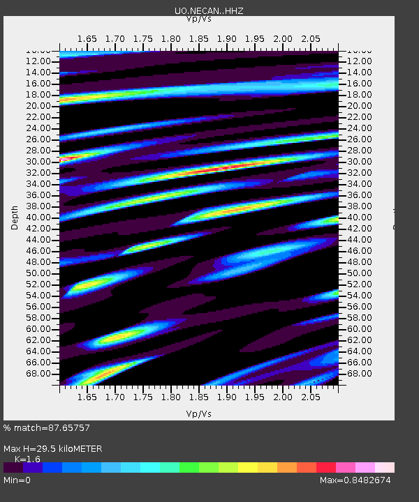
| Estimated Moho Depth: |
29.5 km |
| Estimated Crust Vp/Vs: |
1.60 |
| Assumed Crust Vp: |
6.566 km/s |
| Estimated Crust Vs: |
4.104 km/s |
| Estimated Crust Poisson's Ratio: |
0.18 |
|
| Radial Match: |
87.65757 % |
| Radial Bump: |
400 |
| Transverse Match: |
76.179306 % |
| Transverse Bump: |
400 |
| SOD ConfigId: |
33437571 |
| Insert Time: |
2024-01-15 08:10:14.689 +0000 |
| GWidth: |
2.5 |
| Max Bumps: |
400 |
| Tol: |
0.001 |
|

Signal To Noise
| Channel | StoN | STA | LTA |
| UO:NECAN: :HHZ:20240101T07:20:50.22998Z | 2.1911464 | 1.456084E-6 | 6.6453066E-7 |
| UO:NECAN: :HHN:20240101T07:20:50.22998Z | 0.71392643 | 9.306002E-7 | 1.3034959E-6 |
| UO:NECAN: :HHE:20240101T07:20:50.22998Z | 0.75873244 | 5.4773193E-7 | 7.219039E-7 |
| Arrivals |
| Ps | 2.8 SECOND |
| PpPs | 11 SECOND |
| PsPs/PpSs | 14 SECOND |


