You are here: Home > Network List > UO - University of Oregon Regional Network Stations List
> Station PINE Pine Mountain Observatory, OR > Earthquake Result Viewer
PINE Pine Mountain Observatory, OR - Earthquake Result Viewer
| Earthquake location: |
Near West Coast Of Honshu, Japan |
| Earthquake latitude/longitude: |
37.5/137.2 |
| Earthquake time(UTC): |
2024/01/01 (001) 07:10:10 GMT |
| Earthquake Depth: |
0.0 km |
| Earthquake Magnitude: |
7.4 Mi |
| Earthquake Catalog/Contributor: |
NEIC PDE/pt |
|
| Network: |
UO University of Oregon Regional Network |
| Station: |
PINE Pine Mountain Observatory, OR |
| Lat/Lon: |
43.79 N/120.94 W |
| Elevation: |
1916 m |
|
| Distance: |
72.6 deg |
| Az: |
47.975 deg |
| Baz: |
305.329 deg |
| Ray Param: |
0.05360814 |
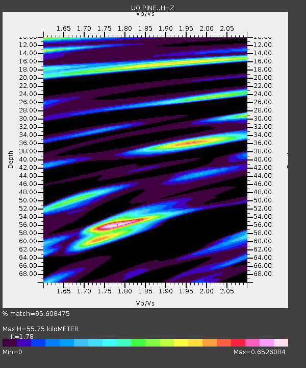
| Estimated Moho Depth: |
55.75 km |
| Estimated Crust Vp/Vs: |
1.78 |
| Assumed Crust Vp: |
6.597 km/s |
| Estimated Crust Vs: |
3.706 km/s |
| Estimated Crust Poisson's Ratio: |
0.27 |
|
| Radial Match: |
95.608475 % |
| Radial Bump: |
400 |
| Transverse Match: |
89.82694 % |
| Transverse Bump: |
400 |
| SOD ConfigId: |
33437571 |
| Insert Time: |
2024-01-15 08:10:23.402 +0000 |
| GWidth: |
2.5 |
| Max Bumps: |
400 |
| Tol: |
0.001 |
|

Signal To Noise
| Channel | StoN | STA | LTA |
| UO:PINE: :HHZ:20240101T07:21:07.530029Z | 6.626055 | 1.8358103E-6 | 2.7705934E-7 |
| UO:PINE: :HHN:20240101T07:21:07.530029Z | 1.6103749 | 7.250942E-7 | 4.502642E-7 |
| UO:PINE: :HHE:20240101T07:21:07.530029Z | 1.4004438 | 6.118735E-7 | 4.3691398E-7 |
| Arrivals |
| Ps | 6.8 SECOND |
| PpPs | 23 SECOND |
| PsPs/PpSs | 29 SECOND |


