You are here: Home > Network List > US - United States National Seismic Network Stations List
> Station DGMT Dagmar, Montana, USA > Earthquake Result Viewer
DGMT Dagmar, Montana, USA - Earthquake Result Viewer
| Earthquake location: |
Near West Coast Of Honshu, Japan |
| Earthquake latitude/longitude: |
37.5/137.2 |
| Earthquake time(UTC): |
2024/01/01 (001) 07:10:10 GMT |
| Earthquake Depth: |
0.0 km |
| Earthquake Magnitude: |
7.4 Mi |
| Earthquake Catalog/Contributor: |
NEIC PDE/pt |
|
| Network: |
US United States National Seismic Network |
| Station: |
DGMT Dagmar, Montana, USA |
| Lat/Lon: |
48.47 N/104.20 W |
| Elevation: |
646 m |
|
| Distance: |
78.5 deg |
| Az: |
36.599 deg |
| Baz: |
314.56 deg |
| Ray Param: |
0.049608085 |
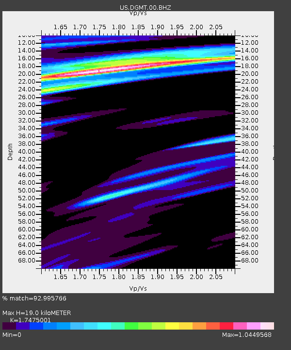
| Estimated Moho Depth: |
19.0 km |
| Estimated Crust Vp/Vs: |
1.75 |
| Assumed Crust Vp: |
6.438 km/s |
| Estimated Crust Vs: |
3.684 km/s |
| Estimated Crust Poisson's Ratio: |
0.26 |
|
| Radial Match: |
92.995766 % |
| Radial Bump: |
244 |
| Transverse Match: |
75.750015 % |
| Transverse Bump: |
364 |
| SOD ConfigId: |
33437571 |
| Insert Time: |
2024-01-15 08:11:28.046 +0000 |
| GWidth: |
2.5 |
| Max Bumps: |
400 |
| Tol: |
0.001 |
|
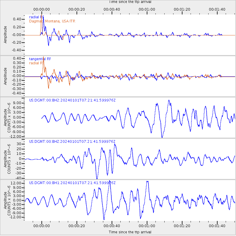
Signal To Noise
| Channel | StoN | STA | LTA |
| US:DGMT:00:BHZ:20240101T07:21:41.599976Z | 4.1986084 | 1.7274402E-6 | 4.114316E-7 |
| US:DGMT:00:BH1:20240101T07:21:41.599976Z | 1.5822601 | 2.283005E-6 | 1.4428758E-6 |
| US:DGMT:00:BH2:20240101T07:21:41.599976Z | 0.57196176 | 1.0722562E-6 | 1.874699E-6 |
| Arrivals |
| Ps | 2.3 SECOND |
| PpPs | 7.9 SECOND |
| PsPs/PpSs | 10 SECOND |


