You are here: Home > Network List > US - United States National Seismic Network Stations List
> Station MNTX Cornudas Mountains, Texas, USA > Earthquake Result Viewer
MNTX Cornudas Mountains, Texas, USA - Earthquake Result Viewer

| Earthquake location: |
Near West Coast Of Honshu, Japan |
| Earthquake latitude/longitude: |
37.5/137.2 |
| Earthquake time(UTC): |
2024/01/01 (001) 07:10:10 GMT |
| Earthquake Depth: |
0.0 km |
| Earthquake Magnitude: |
7.4 Mi |
| Earthquake Catalog/Contributor: |
NEIC PDE/pt |
|
| Network: |
US United States National Seismic Network |
| Station: |
MNTX Cornudas Mountains, Texas, USA |
| Lat/Lon: |
31.70 N/105.38 W |
| Elevation: |
405 m |
|
| Distance: |
89.7 deg |
| Az: |
49.17 deg |
| Baz: |
315.09 deg |
| Ray Param: |
0.041732747 |
| Estimated Moho Depth: |
60.75 km |
| Estimated Crust Vp/Vs: |
1.65 |
| Assumed Crust Vp: |
6.361 km/s |
| Estimated Crust Vs: |
3.843 km/s |
| Estimated Crust Poisson's Ratio: |
0.21 |
|
| Radial Match: |
95.38805 % |
| Radial Bump: |
339 |
| Transverse Match: |
92.0078 % |
| Transverse Bump: |
400 |
| SOD ConfigId: |
33437571 |
| Insert Time: |
2024-01-15 08:11:53.110 +0000 |
| GWidth: |
2.5 |
| Max Bumps: |
400 |
| Tol: |
0.001 |
|
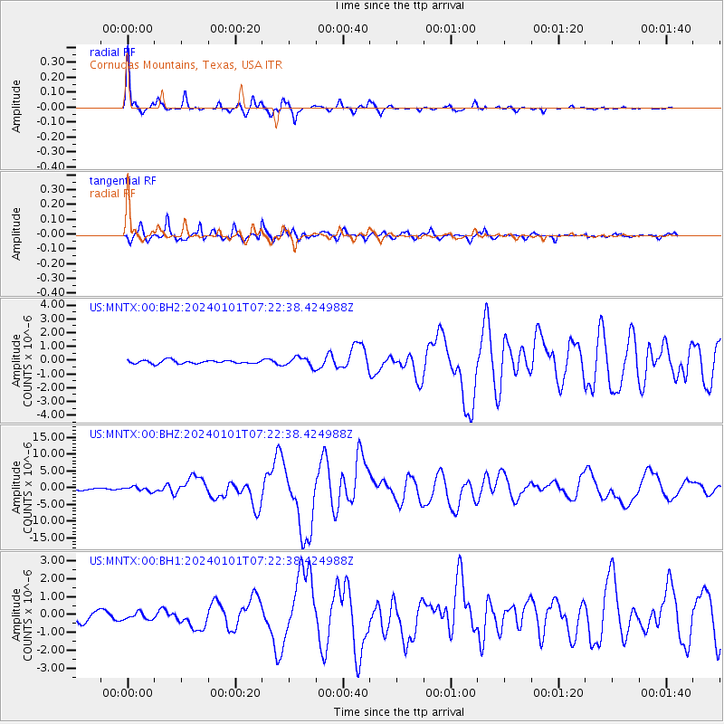
Signal To Noise
| Channel | StoN | STA | LTA |
| US:MNTX:00:BHZ:20240101T07:22:38.424988Z | 1.7731884 | 6.6985064E-7 | 3.777662E-7 |
| US:MNTX:00:BH1:20240101T07:22:38.424988Z | 0.5714623 | 1.9036426E-7 | 3.331178E-7 |
| US:MNTX:00:BH2:20240101T07:22:38.424988Z | 2.768725 | 3.3150957E-7 | 1.1973366E-7 |
| Arrivals |
| Ps | 6.4 SECOND |
| PpPs | 25 SECOND |
| PsPs/PpSs | 31 SECOND |


