You are here: Home > Network List > UU - University of Utah Regional Network Stations List
> Station CCUT Cedar City, UT, USA > Earthquake Result Viewer
CCUT Cedar City, UT, USA - Earthquake Result Viewer
| Earthquake location: |
Near West Coast Of Honshu, Japan |
| Earthquake latitude/longitude: |
37.5/137.2 |
| Earthquake time(UTC): |
2024/01/01 (001) 07:10:10 GMT |
| Earthquake Depth: |
0.0 km |
| Earthquake Magnitude: |
7.4 Mi |
| Earthquake Catalog/Contributor: |
NEIC PDE/pt |
|
| Network: |
UU University of Utah Regional Network |
| Station: |
CCUT Cedar City, UT, USA |
| Lat/Lon: |
37.55 N/113.36 W |
| Elevation: |
2127 m |
|
| Distance: |
80.9 deg |
| Az: |
49.373 deg |
| Baz: |
310.582 deg |
| Ray Param: |
0.047957055 |
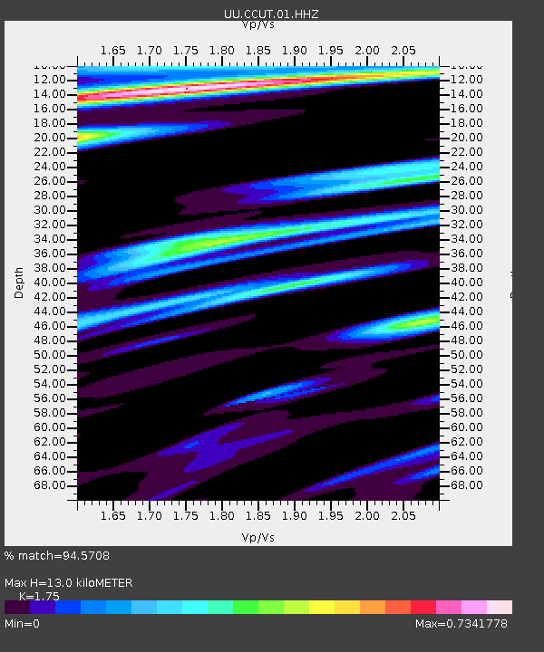
| Estimated Moho Depth: |
13.0 km |
| Estimated Crust Vp/Vs: |
1.75 |
| Assumed Crust Vp: |
6.194 km/s |
| Estimated Crust Vs: |
3.54 km/s |
| Estimated Crust Poisson's Ratio: |
0.26 |
|
| Radial Match: |
94.5708 % |
| Radial Bump: |
400 |
| Transverse Match: |
87.1519 % |
| Transverse Bump: |
400 |
| SOD ConfigId: |
33437571 |
| Insert Time: |
2024-01-15 08:12:14.084 +0000 |
| GWidth: |
2.5 |
| Max Bumps: |
400 |
| Tol: |
0.001 |
|

Signal To Noise
| Channel | StoN | STA | LTA |
| UU:CCUT:01:HHZ:20240101T07:21:54.679993Z | 3.8365393 | 9.582527E-7 | 2.4977007E-7 |
| UU:CCUT:01:HHN:20240101T07:21:54.679993Z | 2.2042763 | 4.5462232E-7 | 2.0624563E-7 |
| UU:CCUT:01:HHE:20240101T07:21:54.679993Z | 0.83619285 | 1.9806707E-7 | 2.3686769E-7 |
| Arrivals |
| Ps | 1.6 SECOND |
| PpPs | 5.6 SECOND |
| PsPs/PpSs | 7.2 SECOND |


