You are here: Home > Network List > UU - University of Utah Regional Network Stations List
> Station FOR7 FORGE > Earthquake Result Viewer
FOR7 FORGE - Earthquake Result Viewer
| Earthquake location: |
Near West Coast Of Honshu, Japan |
| Earthquake latitude/longitude: |
37.5/137.2 |
| Earthquake time(UTC): |
2024/01/01 (001) 07:10:10 GMT |
| Earthquake Depth: |
0.0 km |
| Earthquake Magnitude: |
7.4 Mi |
| Earthquake Catalog/Contributor: |
NEIC PDE/pt |
|
| Network: |
UU University of Utah Regional Network |
| Station: |
FOR7 FORGE |
| Lat/Lon: |
38.42 N/112.85 W |
| Elevation: |
1964 m |
|
| Distance: |
80.7 deg |
| Az: |
48.44 deg |
| Baz: |
310.745 deg |
| Ray Param: |
0.04813496 |
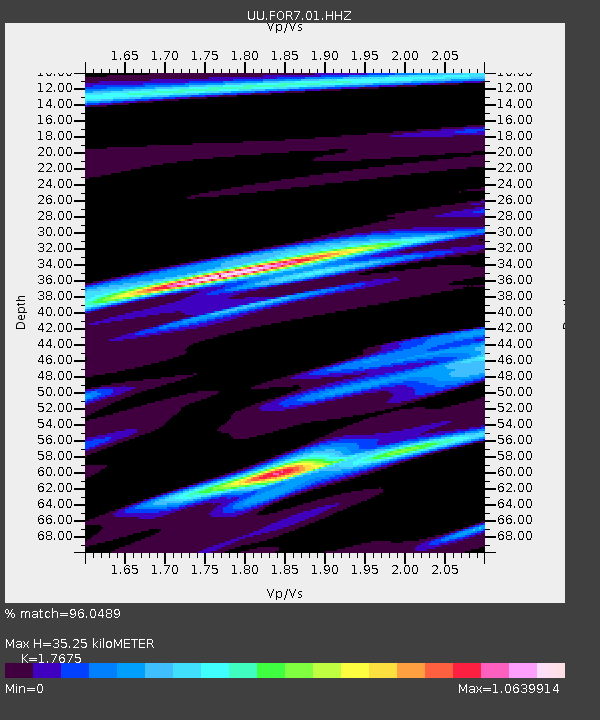
| Estimated Moho Depth: |
35.25 km |
| Estimated Crust Vp/Vs: |
1.77 |
| Assumed Crust Vp: |
6.276 km/s |
| Estimated Crust Vs: |
3.551 km/s |
| Estimated Crust Poisson's Ratio: |
0.26 |
|
| Radial Match: |
96.0489 % |
| Radial Bump: |
240 |
| Transverse Match: |
95.10211 % |
| Transverse Bump: |
342 |
| SOD ConfigId: |
33437571 |
| Insert Time: |
2024-01-15 08:12:22.098 +0000 |
| GWidth: |
2.5 |
| Max Bumps: |
400 |
| Tol: |
0.001 |
|

Signal To Noise
| Channel | StoN | STA | LTA |
| UU:FOR7:01:HHZ:20240101T07:21:53.289978Z | 5.287519 | 9.655987E-7 | 1.8261849E-7 |
| UU:FOR7:01:HHN:20240101T07:21:53.289978Z | 0.66034484 | 1.5850146E-7 | 2.4002833E-7 |
| UU:FOR7:01:HHE:20240101T07:21:53.289978Z | 2.5689337 | 4.1768794E-7 | 1.6259195E-7 |
| Arrivals |
| Ps | 4.4 SECOND |
| PpPs | 15 SECOND |
| PsPs/PpSs | 20 SECOND |


