You are here: Home > Network List > UU - University of Utah Regional Network Stations List
> Station FORU South Mineral Mountains, UT, USA > Earthquake Result Viewer
FORU South Mineral Mountains, UT, USA - Earthquake Result Viewer
| Earthquake location: |
Near West Coast Of Honshu, Japan |
| Earthquake latitude/longitude: |
37.5/137.2 |
| Earthquake time(UTC): |
2024/01/01 (001) 07:10:10 GMT |
| Earthquake Depth: |
0.0 km |
| Earthquake Magnitude: |
7.4 Mi |
| Earthquake Catalog/Contributor: |
NEIC PDE/pt |
|
| Network: |
UU University of Utah Regional Network |
| Station: |
FORU South Mineral Mountains, UT, USA |
| Lat/Lon: |
38.46 N/112.86 W |
| Elevation: |
1840 m |
|
| Distance: |
80.6 deg |
| Az: |
48.415 deg |
| Baz: |
310.736 deg |
| Ray Param: |
0.04815526 |
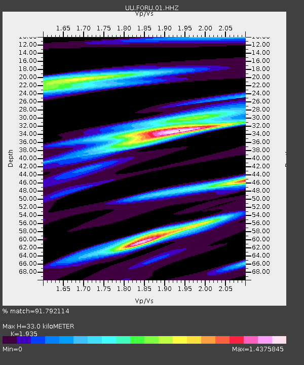
| Estimated Moho Depth: |
33.0 km |
| Estimated Crust Vp/Vs: |
1.93 |
| Assumed Crust Vp: |
6.276 km/s |
| Estimated Crust Vs: |
3.243 km/s |
| Estimated Crust Poisson's Ratio: |
0.32 |
|
| Radial Match: |
91.792114 % |
| Radial Bump: |
400 |
| Transverse Match: |
87.09623 % |
| Transverse Bump: |
400 |
| SOD ConfigId: |
33437571 |
| Insert Time: |
2024-01-15 08:12:25.220 +0000 |
| GWidth: |
2.5 |
| Max Bumps: |
400 |
| Tol: |
0.001 |
|
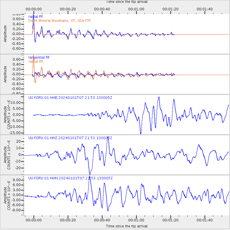
Signal To Noise
| Channel | StoN | STA | LTA |
| UU:FORU:01:HHZ:20240101T07:21:53.130005Z | 4.928157 | 8.849139E-7 | 1.7956286E-7 |
| UU:FORU:01:HHN:20240101T07:21:53.130005Z | 2.0038433 | 7.4990106E-7 | 3.742314E-7 |
| UU:FORU:01:HHE:20240101T07:21:53.130005Z | 2.5114887 | 7.250463E-7 | 2.8869184E-7 |
| Arrivals |
| Ps | 5.0 SECOND |
| PpPs | 15 SECOND |
| PsPs/PpSs | 20 SECOND |


