You are here: Home > Network List > UU - University of Utah Regional Network Stations List
> Station FSB2 FORGE surface borehole 2, UT, USA > Earthquake Result Viewer
FSB2 FORGE surface borehole 2, UT, USA - Earthquake Result Viewer
| Earthquake location: |
Near West Coast Of Honshu, Japan |
| Earthquake latitude/longitude: |
37.5/137.2 |
| Earthquake time(UTC): |
2024/01/01 (001) 07:10:10 GMT |
| Earthquake Depth: |
0.0 km |
| Earthquake Magnitude: |
7.4 Mi |
| Earthquake Catalog/Contributor: |
NEIC PDE/pt |
|
| Network: |
UU University of Utah Regional Network |
| Station: |
FSB2 FORGE surface borehole 2, UT, USA |
| Lat/Lon: |
38.51 N/112.88 W |
| Elevation: |
1587 m |
|
| Distance: |
80.6 deg |
| Az: |
48.388 deg |
| Baz: |
310.719 deg |
| Ray Param: |
0.04818388 |
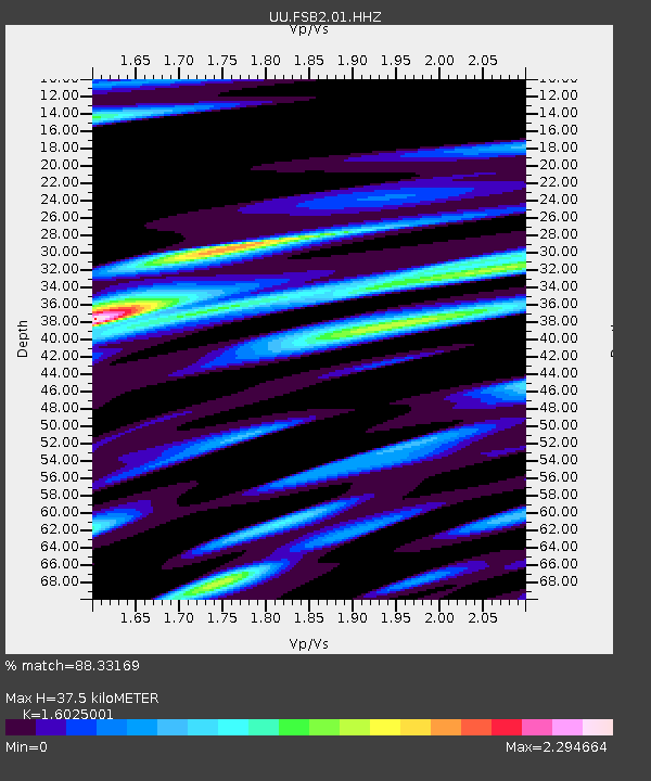
| Estimated Moho Depth: |
37.5 km |
| Estimated Crust Vp/Vs: |
1.60 |
| Assumed Crust Vp: |
6.276 km/s |
| Estimated Crust Vs: |
3.916 km/s |
| Estimated Crust Poisson's Ratio: |
0.18 |
|
| Radial Match: |
88.33169 % |
| Radial Bump: |
400 |
| Transverse Match: |
67.60638 % |
| Transverse Bump: |
400 |
| SOD ConfigId: |
33437571 |
| Insert Time: |
2024-01-15 08:12:28.417 +0000 |
| GWidth: |
2.5 |
| Max Bumps: |
400 |
| Tol: |
0.001 |
|

Signal To Noise
| Channel | StoN | STA | LTA |
| UU:FSB2:01:HHZ:20240101T07:21:52.789978Z | 3.7558327 | 1.2216507E-6 | 3.2526762E-7 |
| UU:FSB2:01:HH1:20240101T07:21:52.789978Z | 2.6756504 | 1.1301345E-6 | 4.223775E-7 |
| UU:FSB2:01:HH2:20240101T07:21:52.789978Z | 1.6252637 | 6.0993943E-7 | 3.7528645E-7 |
| Arrivals |
| Ps | 3.7 SECOND |
| PpPs | 15 SECOND |
| PsPs/PpSs | 19 SECOND |


