You are here: Home > Network List > UU - University of Utah Regional Network Stations List
> Station MPU Maple Canyon, UT, USA > Earthquake Result Viewer
MPU Maple Canyon, UT, USA - Earthquake Result Viewer
| Earthquake location: |
Near West Coast Of Honshu, Japan |
| Earthquake latitude/longitude: |
37.5/137.2 |
| Earthquake time(UTC): |
2024/01/01 (001) 07:10:10 GMT |
| Earthquake Depth: |
0.0 km |
| Earthquake Magnitude: |
7.4 Mi |
| Earthquake Catalog/Contributor: |
NEIC PDE/pt |
|
| Network: |
UU University of Utah Regional Network |
| Station: |
MPU Maple Canyon, UT, USA |
| Lat/Lon: |
40.02 N/111.63 W |
| Elevation: |
1909 m |
|
| Distance: |
80.3 deg |
| Az: |
46.591 deg |
| Baz: |
311.208 deg |
| Ray Param: |
0.048361573 |
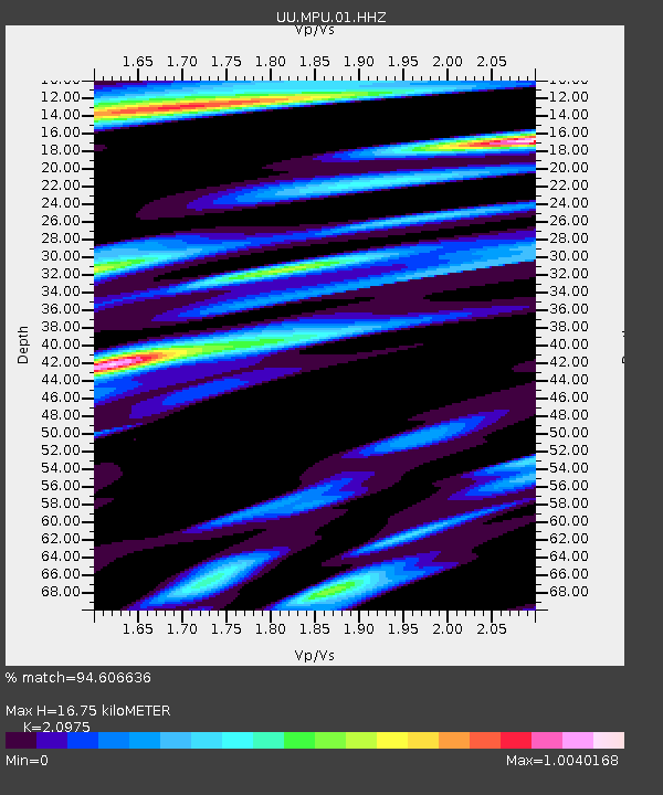
| Estimated Moho Depth: |
16.75 km |
| Estimated Crust Vp/Vs: |
2.10 |
| Assumed Crust Vp: |
6.155 km/s |
| Estimated Crust Vs: |
2.934 km/s |
| Estimated Crust Poisson's Ratio: |
0.35 |
|
| Radial Match: |
94.606636 % |
| Radial Bump: |
400 |
| Transverse Match: |
77.40759 % |
| Transverse Bump: |
400 |
| SOD ConfigId: |
33437571 |
| Insert Time: |
2024-01-15 08:12:47.472 +0000 |
| GWidth: |
2.5 |
| Max Bumps: |
400 |
| Tol: |
0.001 |
|

Signal To Noise
| Channel | StoN | STA | LTA |
| UU:MPU:01:HHZ:20240101T07:21:51.530029Z | 4.0650387 | 1.0352634E-6 | 2.5467492E-7 |
| UU:MPU:01:HHN:20240101T07:21:51.530029Z | 2.2570693 | 4.245296E-7 | 1.8808885E-7 |
| UU:MPU:01:HHE:20240101T07:21:51.530029Z | 1.5290747 | 3.162262E-7 | 2.0680885E-7 |
| Arrivals |
| Ps | 3.1 SECOND |
| PpPs | 8.2 SECOND |
| PsPs/PpSs | 11 SECOND |


