You are here: Home > Network List > UU - University of Utah Regional Network Stations List
> Station HDUT Hyde Park, UT > Earthquake Result Viewer
HDUT Hyde Park, UT - Earthquake Result Viewer
| Earthquake location: |
Near West Coast Of Honshu, Japan |
| Earthquake latitude/longitude: |
37.5/137.2 |
| Earthquake time(UTC): |
2024/01/01 (001) 07:10:10 GMT |
| Earthquake Depth: |
0.0 km |
| Earthquake Magnitude: |
7.4 Mi |
| Earthquake Catalog/Contributor: |
NEIC PDE/pt |
|
| Network: |
UU University of Utah Regional Network |
| Station: |
HDUT Hyde Park, UT |
| Lat/Lon: |
41.80 N/111.77 W |
| Elevation: |
1846 m |
|
| Distance: |
79.1 deg |
| Az: |
45.289 deg |
| Baz: |
310.89 deg |
| Ray Param: |
0.049215958 |
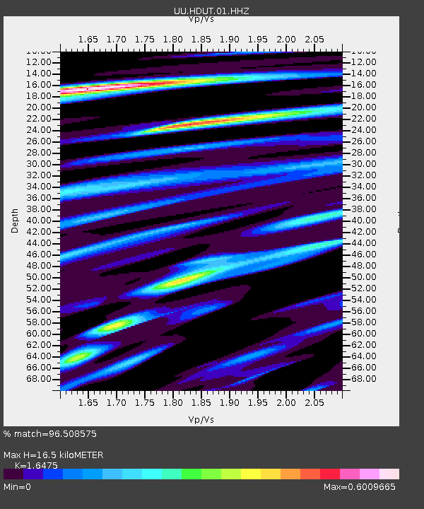
| Estimated Moho Depth: |
16.5 km |
| Estimated Crust Vp/Vs: |
1.65 |
| Assumed Crust Vp: |
6.155 km/s |
| Estimated Crust Vs: |
3.736 km/s |
| Estimated Crust Poisson's Ratio: |
0.21 |
|
| Radial Match: |
96.508575 % |
| Radial Bump: |
389 |
| Transverse Match: |
95.12402 % |
| Transverse Bump: |
400 |
| SOD ConfigId: |
33437571 |
| Insert Time: |
2024-01-15 08:12:57.663 +0000 |
| GWidth: |
2.5 |
| Max Bumps: |
400 |
| Tol: |
0.001 |
|

Signal To Noise
| Channel | StoN | STA | LTA |
| UU:HDUT:01:HHZ:20240101T07:21:44.780029Z | 5.5401263 | 1.265504E-6 | 2.2842512E-7 |
| UU:HDUT:01:HHN:20240101T07:21:44.780029Z | 1.2597761 | 2.0856595E-7 | 1.6555795E-7 |
| UU:HDUT:01:HHE:20240101T07:21:44.780029Z | 2.9040918 | 6.49694E-7 | 2.2371675E-7 |
| Arrivals |
| Ps | 1.8 SECOND |
| PpPs | 6.9 SECOND |
| PsPs/PpSs | 8.7 SECOND |


