You are here: Home > Network List > UW - Pacific Northwest Regional Seismic Network Stations List
> Station BDGR Fisse-Smith Property, Kittitas, WA, USA > Earthquake Result Viewer
BDGR Fisse-Smith Property, Kittitas, WA, USA - Earthquake Result Viewer
| Earthquake location: |
Near West Coast Of Honshu, Japan |
| Earthquake latitude/longitude: |
37.5/137.2 |
| Earthquake time(UTC): |
2024/01/01 (001) 07:10:10 GMT |
| Earthquake Depth: |
0.0 km |
| Earthquake Magnitude: |
7.4 Mi |
| Earthquake Catalog/Contributor: |
NEIC PDE/pt |
|
| Network: |
UW Pacific Northwest Regional Seismic Network |
| Station: |
BDGR Fisse-Smith Property, Kittitas, WA, USA |
| Lat/Lon: |
46.86 N/120.30 W |
| Elevation: |
642 m |
|
| Distance: |
71.2 deg |
| Az: |
45.062 deg |
| Baz: |
304.878 deg |
| Ray Param: |
0.05451837 |
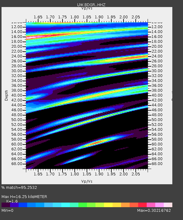
| Estimated Moho Depth: |
16.25 km |
| Estimated Crust Vp/Vs: |
1.60 |
| Assumed Crust Vp: |
6.597 km/s |
| Estimated Crust Vs: |
4.123 km/s |
| Estimated Crust Poisson's Ratio: |
0.18 |
|
| Radial Match: |
95.2532 % |
| Radial Bump: |
400 |
| Transverse Match: |
86.27854 % |
| Transverse Bump: |
400 |
| SOD ConfigId: |
33437571 |
| Insert Time: |
2024-01-15 08:13:13.036 +0000 |
| GWidth: |
2.5 |
| Max Bumps: |
400 |
| Tol: |
0.001 |
|

Signal To Noise
| Channel | StoN | STA | LTA |
| UW:BDGR: :HHZ:20240101T07:20:59.190002Z | 3.9027927 | 1.6209235E-6 | 4.15324E-7 |
| UW:BDGR: :HHN:20240101T07:20:59.190002Z | 1.0865054 | 2.785389E-7 | 2.5636217E-7 |
| UW:BDGR: :HHE:20240101T07:20:59.190002Z | 0.84299797 | 3.9909787E-7 | 4.7342687E-7 |
| Arrivals |
| Ps | 1.5 SECOND |
| PpPs | 6.1 SECOND |
| PsPs/PpSs | 7.7 SECOND |


