You are here: Home > Network List > UW - Pacific Northwest Regional Seismic Network Stations List
> Station COWL Weyerhaeuser Mt St Helens Tree Farm, Lewis County, WA, USA > Earthquake Result Viewer
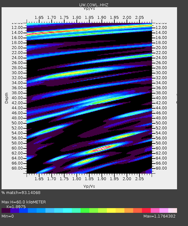
COWL Weyerhaeuser Mt St Helens Tree Farm, Lewis County, WA, USA - Earthquake Result Viewer
| Earthquake location: |
Near West Coast Of Honshu, Japan |
| Earthquake latitude/longitude: |
37.5/137.2 |
| Earthquake time(UTC): |
2024/01/01 (001) 07:10:10 GMT |
| Earthquake Depth: |
0.0 km |
| Earthquake Magnitude: |
7.4 Mi |
| Earthquake Catalog/Contributor: |
NEIC PDE/pt |
|
| Network: |
UW Pacific Northwest Regional Seismic Network |
| Station: |
COWL Weyerhaeuser Mt St Helens Tree Farm, Lewis County, WA, USA |
| Lat/Lon: |
46.48 N/122.66 W |
| Elevation: |
183 m |
|
| Distance: |
70.0 deg |
| Az: |
46.363 deg |
| Baz: |
303.594 deg |
| Ray Param: |
0.055284742 |
| Estimated Moho Depth: |
60.0 km |
| Estimated Crust Vp/Vs: |
1.90 |
| Assumed Crust Vp: |
6.566 km/s |
| Estimated Crust Vs: |
3.46 km/s |
| Estimated Crust Poisson's Ratio: |
0.31 |
|
| Radial Match: |
93.14068 % |
| Radial Bump: |
400 |
| Transverse Match: |
80.81623 % |
| Transverse Bump: |
400 |
| SOD ConfigId: |
33437571 |
| Insert Time: |
2024-01-15 08:13:39.583 +0000 |
| GWidth: |
2.5 |
| Max Bumps: |
400 |
| Tol: |
0.001 |
|

Signal To Noise
| Channel | StoN | STA | LTA |
| UW:COWL: :HHZ:20240101T07:20:52.27002Z | 6.7032037 | 2.1742599E-6 | 3.243613E-7 |
| UW:COWL: :HHN:20240101T07:20:52.27002Z | 1.1349102 | 8.6033486E-7 | 7.580643E-7 |
| UW:COWL: :HHE:20240101T07:20:52.27002Z | 1.3906478 | 7.314284E-7 | 5.259624E-7 |
| Arrivals |
| Ps | 8.5 SECOND |
| PpPs | 26 SECOND |
| PsPs/PpSs | 34 SECOND |


