You are here: Home > Network List > UW - Pacific Northwest Regional Seismic Network Stations List
> Station CROWN Crown Point, Clallam County, WA, USA > Earthquake Result Viewer
CROWN Crown Point, Clallam County, WA, USA - Earthquake Result Viewer
| Earthquake location: |
Near West Coast Of Honshu, Japan |
| Earthquake latitude/longitude: |
37.5/137.2 |
| Earthquake time(UTC): |
2024/01/01 (001) 07:10:10 GMT |
| Earthquake Depth: |
0.0 km |
| Earthquake Magnitude: |
7.4 Mi |
| Earthquake Catalog/Contributor: |
NEIC PDE/pt |
|
| Network: |
UW Pacific Northwest Regional Seismic Network |
| Station: |
CROWN Crown Point, Clallam County, WA, USA |
| Lat/Lon: |
48.30 N/124.48 W |
| Elevation: |
399 m |
|
| Distance: |
68.0 deg |
| Az: |
45.437 deg |
| Baz: |
301.931 deg |
| Ray Param: |
0.05660773 |
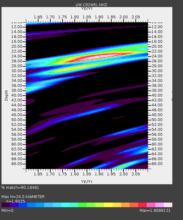
| Estimated Moho Depth: |
24.0 km |
| Estimated Crust Vp/Vs: |
1.90 |
| Assumed Crust Vp: |
6.391 km/s |
| Estimated Crust Vs: |
3.359 km/s |
| Estimated Crust Poisson's Ratio: |
0.31 |
|
| Radial Match: |
90.16461 % |
| Radial Bump: |
400 |
| Transverse Match: |
82.88634 % |
| Transverse Bump: |
400 |
| SOD ConfigId: |
33437571 |
| Insert Time: |
2024-01-15 08:13:44.759 +0000 |
| GWidth: |
2.5 |
| Max Bumps: |
400 |
| Tol: |
0.001 |
|

Signal To Noise
| Channel | StoN | STA | LTA |
| UW:CROWN: :HHZ:20240101T07:20:39.73999Z | 2.6105173 | 1.4472336E-6 | 5.5438574E-7 |
| UW:CROWN: :HHN:20240101T07:20:39.73999Z | 1.2971777 | 1.2342762E-6 | 9.51509E-7 |
| UW:CROWN: :HHE:20240101T07:20:39.73999Z | 1.0960822 | 8.699622E-7 | 7.937016E-7 |
| Arrivals |
| Ps | 3.5 SECOND |
| PpPs | 11 SECOND |
| PsPs/PpSs | 14 SECOND |


