You are here: Home > Network List > UW - Pacific Northwest Regional Seismic Network Stations List
> Station GBB GBB, Hanford, WA, USA > Earthquake Result Viewer
GBB GBB, Hanford, WA, USA - Earthquake Result Viewer
| Earthquake location: |
Near West Coast Of Honshu, Japan |
| Earthquake latitude/longitude: |
37.5/137.2 |
| Earthquake time(UTC): |
2024/01/01 (001) 07:10:10 GMT |
| Earthquake Depth: |
0.0 km |
| Earthquake Magnitude: |
7.4 Mi |
| Earthquake Catalog/Contributor: |
NEIC PDE/pt |
|
| Network: |
UW Pacific Northwest Regional Seismic Network |
| Station: |
GBB GBB, Hanford, WA, USA |
| Lat/Lon: |
46.61 N/119.63 W |
| Elevation: |
185 m |
|
| Distance: |
71.7 deg |
| Az: |
44.998 deg |
| Baz: |
305.343 deg |
| Ray Param: |
0.054191712 |
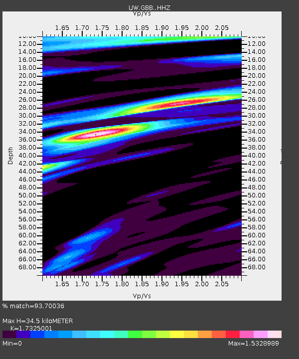
| Estimated Moho Depth: |
34.5 km |
| Estimated Crust Vp/Vs: |
1.73 |
| Assumed Crust Vp: |
6.419 km/s |
| Estimated Crust Vs: |
3.705 km/s |
| Estimated Crust Poisson's Ratio: |
0.25 |
|
| Radial Match: |
93.70036 % |
| Radial Bump: |
400 |
| Transverse Match: |
81.8187 % |
| Transverse Bump: |
400 |
| SOD ConfigId: |
33437571 |
| Insert Time: |
2024-01-15 08:14:11.120 +0000 |
| GWidth: |
2.5 |
| Max Bumps: |
400 |
| Tol: |
0.001 |
|

Signal To Noise
| Channel | StoN | STA | LTA |
| UW:GBB: :HHZ:20240101T07:21:02.320007Z | 3.419184 | 1.1646126E-6 | 3.406113E-7 |
| UW:GBB: :HHN:20240101T07:21:02.320007Z | 2.4274225 | 3.986102E-7 | 1.642113E-7 |
| UW:GBB: :HHE:20240101T07:21:02.320007Z | 2.1606345 | 7.2677193E-7 | 3.3636968E-7 |
| Arrivals |
| Ps | 4.1 SECOND |
| PpPs | 14 SECOND |
| PsPs/PpSs | 18 SECOND |


