You are here: Home > Network List > UW - Pacific Northwest Regional Seismic Network Stations List
> Station KTSAP Belfair, WA, USA > Earthquake Result Viewer
KTSAP Belfair, WA, USA - Earthquake Result Viewer
| Earthquake location: |
Near West Coast Of Honshu, Japan |
| Earthquake latitude/longitude: |
37.5/137.2 |
| Earthquake time(UTC): |
2024/01/01 (001) 07:10:10 GMT |
| Earthquake Depth: |
0.0 km |
| Earthquake Magnitude: |
7.4 Mi |
| Earthquake Catalog/Contributor: |
NEIC PDE/pt |
|
| Network: |
UW Pacific Northwest Regional Seismic Network |
| Station: |
KTSAP Belfair, WA, USA |
| Lat/Lon: |
47.52 N/122.94 W |
| Elevation: |
167 m |
|
| Distance: |
69.3 deg |
| Az: |
45.55 deg |
| Baz: |
303.112 deg |
| Ray Param: |
0.05575737 |
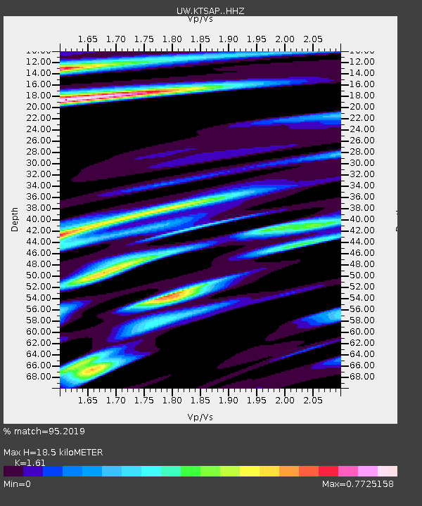
| Estimated Moho Depth: |
18.5 km |
| Estimated Crust Vp/Vs: |
1.61 |
| Assumed Crust Vp: |
6.566 km/s |
| Estimated Crust Vs: |
4.078 km/s |
| Estimated Crust Poisson's Ratio: |
0.19 |
|
| Radial Match: |
95.2019 % |
| Radial Bump: |
400 |
| Transverse Match: |
90.56255 % |
| Transverse Bump: |
400 |
| SOD ConfigId: |
33437571 |
| Insert Time: |
2024-01-15 08:14:42.589 +0000 |
| GWidth: |
2.5 |
| Max Bumps: |
400 |
| Tol: |
0.001 |
|

Signal To Noise
| Channel | StoN | STA | LTA |
| UW:KTSAP: :HHZ:20240101T07:20:47.799988Z | 3.5431852 | 1.6097777E-6 | 4.5433066E-7 |
| UW:KTSAP: :HHN:20240101T07:20:47.799988Z | 1.3287132 | 4.9384266E-7 | 3.7166987E-7 |
| UW:KTSAP: :HHE:20240101T07:20:47.799988Z | 0.6546542 | 6.156441E-7 | 9.404112E-7 |
| Arrivals |
| Ps | 1.8 SECOND |
| PpPs | 7.0 SECOND |
| PsPs/PpSs | 8.8 SECOND |


