You are here: Home > Network List > TA - USArray Transportable Network (new EarthScope stations) Stations List
> Station X33A Lawton, OK, USA > Earthquake Result Viewer
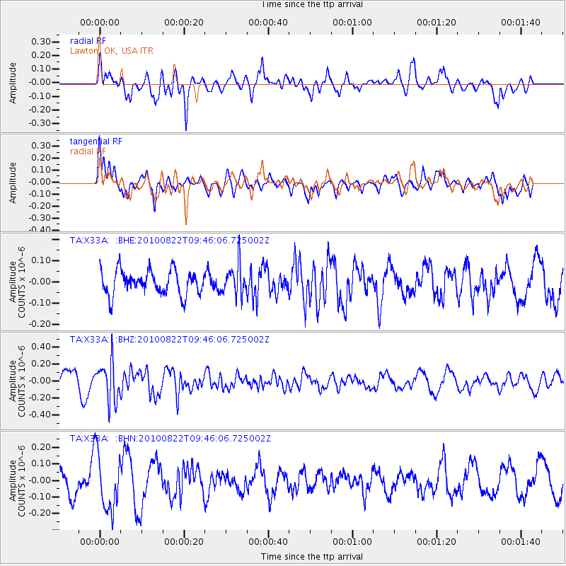
X33A Lawton, OK, USA - Earthquake Result Viewer
*The percent match for this event was below the threshold and hence no stack was calculated.
| Earthquake location: |
Mariana Islands Region |
| Earthquake latitude/longitude: |
19.4/147.4 |
| Earthquake time(UTC): |
2010/08/22 (234) 09:33:06 GMT |
| Earthquake Depth: |
23 km |
| Earthquake Magnitude: |
5.9 MB, 5.3 MS, 5.5 MW |
| Earthquake Catalog/Contributor: |
WHDF/NEIC |
|
| Network: |
TA USArray Transportable Network (new EarthScope stations) |
| Station: |
X33A Lawton, OK, USA |
| Lat/Lon: |
34.54 N/98.50 W |
| Elevation: |
346 m |
|
| Distance: |
97.6 deg |
| Az: |
49.466 deg |
| Baz: |
299.675 deg |
| Ray Param: |
$rayparam |
*The percent match for this event was below the threshold and hence was not used in the summary stack. |
|
| Radial Match: |
66.48736 % |
| Radial Bump: |
400 |
| Transverse Match: |
72.45571 % |
| Transverse Bump: |
400 |
| SOD ConfigId: |
319893 |
| Insert Time: |
2011-01-06 01:41:34.385 +0000 |
| GWidth: |
2.5 |
| Max Bumps: |
400 |
| Tol: |
0.001 |
|
Signal To Noise
| Channel | StoN | STA | LTA |
| TA:X33A: :BHZ:20100822T09:46:06.725002Z | 2.2311215 | 2.3411916E-7 | 1.049334E-7 |
| TA:X33A: :BHN:20100822T09:46:06.725002Z | 1.3615292 | 1.6387811E-7 | 1.2036327E-7 |
| TA:X33A: :BHE:20100822T09:46:06.725002Z | 1.2872628 | 7.234458E-8 | 5.6200317E-8 |
| Arrivals |
| Ps | |
| PpPs | |
| PsPs/PpSs | |


